Saint Croix National Scenic Riverway
- Home
- National Sites
- Wisconsin
- Saint Croix National Scenic Riverway
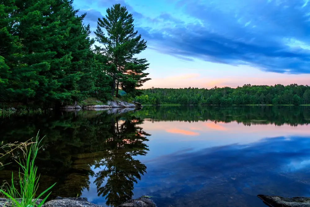
Part of the National Wild and Scenic Rivers System, The Saint Croix National Scenic Riverway is the largest scenic riverway east of the Mississippi River. The riverway protects 252 miles of river and adjacent lands. This area includes the Saint Croix River that runs along the Wisconsin-Minnesota border and the Namekagon River in Wisconsin. The riverway offers hiking, biking, fishing, and boating in the summer and several trails for cross country skiing in winter, making it a perfect destination no matter the season.
Things To Do Near Saint Croix National Scenic Riverway
Spanning more than 200 miles of waterways and connected lands, the Saint Croix National Scenic Riverway offers visitors the opportunity to explore a variety of natural landscapes. Hiking and biking trails wind through woods and reveal stunning views from atop river bluffs. The rivers offer excellent fishing and boating and plenty of opportunities for primitive camping along the shore.
 Hiking Trails
-
Indianhead Flowage Trail
This trail is a level walk through woods and over streams to the river. In the spring, blooming wildflowers paint the path in riotous color. Late summer visitors might be lucky enough to find wild berries growing along the trail, perfect for a snack on the go. Because hunting is permitted in the area, hikers must wear blaze orange during hunting season.
Location
Ice Age Trail sign at Lion’s Park in St. Croix Falls, WI, just off Highway 87
Length
0.75 miles
Intensity
Easy
-
St. Croix Trail
Explore this shoreline trail for an afternoon or pack up your gear and spend the night at one of the primitive campsites along the shoreline. The trail crosses several streams lined with blooming wildflowers in the spring. Observant hikers will notice that beavers in this area have built lodges in the banks of the St. Croix River. Because the river is too wide for them to fully dam, beavers will instead burrow into the river banks to make their homes. The area is also home to several bald eagle nests, so keep an eye on the sky, and you might see one of the majestic birds in flight. Hikers must wear blaze orange for safety during hunting season.
Location
Tamarack Forest Road north of Hinckley, Minnesota
Length
12 miles (one way)
Intensity
Easy
-
Trego Lake Trail
This triple loop trail runs along the banks of the Namekagon River and Trego Lake. Hikers are treated to stunning overlooks of the 383-acre Trego Lake. The pathway is also a good place to spot a white-tailed deer or ruffed grouse. For safety, hikers should wear blaze orange during hunting season.
Location
2 miles west of 53 on River Road, Trego, Wisconsin
Length
3.6 miles
Intensity
Moderate
 Sightseeing
-
Taylor Falls Scenic Boat Tours
Hop aboard an authentic paddlewheel riverboat and explore the St. Croix River in style. Knowledgeable guides will help you spot points of interest along the journey, including the stone cross rock formation for which the river was named and The Old Man of Dalles. Daily excursions are offered in either 45- or 80-minute durations. Reservations for the daily scenic tours are not required but are recommended. Specialty-themed cruises are also available throughout the year.
Location
220 South St., Taylors Falls, MN 55084
-
Interstate State Park
Interstate State Park offers visitors over seven miles of hiking trails through glacier-carved rock formations, wooded areas, and down to a lakeside beach. The park also offers fishing, hunting, boating, and rock climbing.
Location
1275 WI-35, St. Croix Falls, WI 54024
-
Wild Mountain
In the summer, stop by to embark on a wet and wild adventure. With water slides, a splash park, and a lazy river, it’s the perfect place to cool off on a hot summer day. When you need a break to dry off, check out the go-karts or the alpine slide that runs 1700 feet from top to bottom. If you happen to be traveling during the winter, bundle up and hit the slopes of Wild Mountain for skiing, tubing, and other winter activities.
Location
37200 Wild Mountain Road, Taylors Falls, MN 55084
 Museums
-
Folsom House
Built by lumber baron and six-term state senator William Folsom in 1885, the Folsom House reflects the Greek Revival Style. The home remained in the Folsom family for five generations, and today, visitors to the home will have the unique opportunity to see it much as it was when the Folsom family lived there. Of particular note are the grand piano, Folsom’s extensive library, clothing, and other personal items.
Location
272 W. Government St., Taylors Falls, MN 55084
-
Minnesota Transportation Museum - Museum at Jackson Street Roundhouse
Explore the history of travel at this museum dedicated to regional rail and bus travel. The museum features 50 historic rail cars and a fully operational roundhouse turntable. There are also train rides offered to visitors each Saturday.
Location
193 Pennsylvania Ave., St. Paul, MN, 55130
Nearby Shops and Restaurants
-
Black Letter Books
Find your next paperback read or a rare vintage tome to complete your collection at Black Letter Books. This used bookstore offers gently used books, children’s books, and fine collectible editions.
Location
102 Main St S, Stillwater, MN 55082
-
Midtown Antiques
Midtown Antiques is one of the largest antique malls in the Midwest. Offering items like vintage coins and furniture, there is potential treasure around every corner. With over a million items filling three floors, you’ll need to allow plenty of time to explore Midtown Antiques.
Location
301 Main St. S., Stillwater, MN 55082
-
Taylor Falls Drive-In
Cue up the old rock and roll and drive in for a meal at the Taylor Falls Drive-in. In operation since 1956, the drive-in retains much of its original charm, complete with carhops in poodle skirts and music that will take you back decades. On weekends, you’ll often find classic cars parked at the drive-in.
Location
572 Bench Street, Taylors Falls, MN 55084
-
Juneberry Cafe
Featuring local, sustainable, organic ingredients, you're guaranteed a high-quality meal made with care at Juneberry Cafe. This venue offers to-go meals just right for those out hiking and enjoying nature. The menu includes morning bagel sandwiches and breakfast burritos and hot-pressed sandwiches for lunch.
Location
360 Bench Street, Taylors Falls, MN 55084
How To Get To Saint Croix National Scenic Riverway
There are several points of access to explore the riverway. Minnesota Highway 95 and Wisconsin Highway 35 run parallel to the lower stretch of the St. Croix River. Highway 63 in Wisconsin runs parallel to the upper Namekagon River.
Address
401 North Hamilton Street, St. Croix Falls, WI
Fee: Entry fee $0
The Saint Croix National Scenic Riverway encompasses 252 miles of the scenic river stretching through 11 counties and two states. Offering year-round activities, there is always something to do along the Saint Croix National Scenic Riverway. With so much to explore, an RV trip is an excellent way to experience everything the riverway has to offer.