Coronado National Forest Guide
- Home
- National Forests
- Arizona
- Coronado National Forest
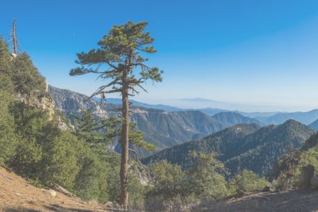
Coronado National Forest in southeastern Arizona covers over 1.7 million acres and features diverse landscapes, from desert to high-mountain regions. The forest is renowned for stunning sights like Mount Wrightson, Saguaro National Park, and the beautiful Chiricahua Mountains. The best times for camping in Coronado National Forest are spring and fall, with moderate temperatures, making hiking and outdoor activities more enjoyable. Summer offers a warmer climate, while winter provides cooler weather and fewer crowds. For RV camping near Coronado, Madera Canyon Campground and Cave Creek Canyon Campground are popular, offering both paid and free sites. Many areas in the forest have amenities like picnic tables and fire rings, making them excellent bases for exploring the diverse ecosystems and scenic views. For an unforgettable outdoor experience, explore the best spots for camping in Arizona, where you can find scenic and accessible locations to park your RV and enjoy the stunning landscapes.
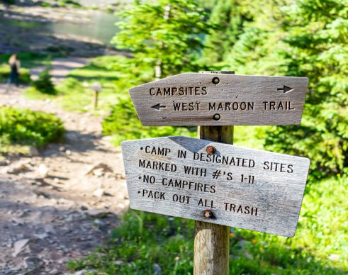
Camping in Coronado National Forest
Coronado National Forest offers several campgrounds for both paid and free camping. Enjoy stunning views, hiking trails, and several RV-friendly sites while camping near Coronado National Forest.
Campgrounds in Coronado National Forest
$15 per night
$15 per night
$25 per night
$30 per night
$20 per night
Private CampgroundsNear Coronado National Forest
Before planning your trip to Coronado National Forest, check out the top campgrounds in Arizona. For more options, you can also explore campgrounds in nearby cities like Tucson or Sierra Vista. Also, check out nearby BLM sites and RV Dump Stations in Arizona.
Campgrounds by Lakes/Rivers for Fishing and Water Activities
$28 per night
$20 per night
$20 per night
$12 per night
Budget-friendly Campgrounds
$15 per night
$20 per night
$15 per night
RV Rentals Near Coronado National Forest
Coronado National Forest Hiking Trails
Discover a variety of hiking trails in Coronado National Forest, offering everything from leisurely walks to challenging treks.
Easy Hikes for Beginners
Distance: 2.2 miles
Difficulty: Easy
Distance: 2.5 miles
Difficulty: Easy
Distance: 2 miles
Difficulty: Easy
Challenging Trails for Hikers
Distance: 8.3 miles
Difficulty: Moderate
Distance: 6.6 miles
Difficulty: Moderate
Distance: 1.9 miles
Difficulty: Hard
Lakeside Trails
Distance: 0.8 miles (loop)
Difficulty: Easy
Distance: 1.5 miles (loop)
Difficulty: Moderate
Distance: 4.5 miles (loop)
Difficulty: Moderate
-
Butterfly Trail
The Butterfly Trail is one of the most popular routes in the Coronado National Forest. It travels through the Mt. Lemmon region, offering spectacular views along the way. More fascinating are the diverse plants and animals that you'll see along the trail; the Forest Service recommends bringing a local guidebook to help identify the trees, flowers, and birds. True to its name, this trail is often frequented by colorful butterflies that flock to the beautiful wildflowers on either side of the path. Come any time; there's plenty of shade.
Length: 5.7 miles
Intensity: Moderate to Difficult
-
Old Baldy Trail
Conquer the 9,543-foot Mt. Wrightson on the Old Baldy Trail. Short but challenging, this trail climbs quickly to the saddle of the tallest peak in the Santa Rita Mountains. It runs through the forest, offering plenty of shade and occasional views. When you reach the Josephine Saddle, hop on the Crest Trail for one mile to get to the summit. The hike is challenging but worthwhile; the views from the top are fantastic. Keep in mind that Old Baldy Trail intersects with the longer and gentler Super Trail, giving you plenty of opportunities to create your own route.
Length: 4.5 miles
Intensity: Difficult
-
Sycamore Canyon Trail
Known for its exceptionally diverse plant and animal life, the Sycamore Canyon Trail is a beautiful hike. It's unexpectedly lush for southern Arizona — that's because a perennial stream flows through the canyon. At the start of the trail, look for the ruins of the homestead that stood during the Civil War years. This route is unique in that it ends at the United States-Mexico border. If you'd like a longer hike, you can walk along the trail that parallels the barbed-wire border fence.
Length: 5.3 miles
Intensity: Moderate
-
Sabino Canyon Trail
The Sabino Canyon Trail is a short trail that takes you through some of the most beautiful scenery in the Coronado National Forest. Hike through the desert and into the canyon, taking plenty of stops to enjoy the view over Tucson and the mountains. If you want a longer hike, you can create a loop using the Sycamore Reservoir and East Fork trails.
Length: 2.5 miles
Intensity: Difficult
-
Bear Canyon Trail
If you like to hike with other people, the Bear Canyon Trail is a great option; there are usually other people on the trail. This popularity is due to the Seven Falls, a beautiful collection of waterfalls and deep pools that form after a rainstorm. Keep in mind that personal vehicles aren't allowed to drive to the main part of the trail. Instead, you can park at the Sabino Canyon parking lot and walk the 1.7 miles to the end of the dirt road or hop on the tram that runs through the area. If you're hiking after a thunderstorm, be sure to bring sturdy shoes with traction to help you on the stream crossings.
Length: 6 miles
Intensity: Moderate to Difficult
-
Quantrell Mine Trail
Enjoy fantastic views without the crowds on the Quantrell Mine Trail, a short and challenging route. At the top, you'll be able to see some of the most fascinating local spots, including the Multiple Mirror Telescope on top of Mt. Hopkins. Bring your camera to capture the Santa Cruz Valley, Madera Canyon, and the foothills of the Santa Rita Mountains. In decades past, the trail was a mountain road that led to many different silver and gold mines. Today, you can see some of the historic equipment. This route is open to bikes until the marked wilderness border.
Length: 1.3 miles
Intensity: Difficult
-
Romero Trail
The Romero Trail travels from the trailhead at Catalina State Park into a beautiful canyon and through the Pusch Ridge Wilderness. Be prepared for a steep, challenging hike to get to Romero Pass. If it's rained recently, be on the lookout for the lovely Romero Pools; they're tucked into the rocks, offering a welcome change from the dry desert air. When the water is deep enough, you can wade or swim. Avoid the intense afternoon heat by starting this hike as early as possible.
Length: 6.6 miles
Intensity: Difficult
Activities in Coronado National Forest
Here are the best things to do at Coronado National Forest:
Hiking: Coronado National Forest boasts 1,000+ miles of hiking, biking, and horseback riding trails. Highlights include Sabino Canyon and the Arizona National Scenic Trail, which span diverse terrains, from deserts to mountaintops.
Boating (Motorized): Boating is available in Coronado National Forest at Parker Canyon Lake, Peña Blanca Lake, and other spots. These spots offer scenic views and are perfect for kayaking, canoeing, or small motorized boats.
Swimming: Swimming in Coronado National Forest is permitted at Peña Blanca Lake and Parker Canyon Lake. Both locations provide refreshing waters for a swim, surrounded by stunning natural landscapes for a perfect outdoor experience.
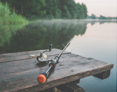
Fishing: Fishing in Coronado National Forest is excellent at the Nogales Ranger District, Safford Ranger District, Santa Catalina Ranger District, and Sierra Vista Ranger District. Anglers can catch bass, trout, or sunfish, while Peña Blanca is popular for stocked rainbow trout.
Horse Riding: Coronado National Forest offers scenic horseback riding trails, such as Gardner Canyon and Box Canyon. Riders can explore diverse terrains, from desert landscapes to forested paths, perfect for an adventurous equestrian experience.
-
Fishing and Water Activities

The hot Arizona sunshine dries up many of the creeks in the forest, but you'll find fishing and watersports at several Forest Service lakes. Check out Arivaca Lake, Frye Mesa Reservoir Lake, Rose Canyon Lake, and Parker Canyon Lake. For boating, your best bet is Riggs Flat or Pena Blanca Lakes.
-
Geocaching

Geocaching is possible away from the designated wilderness areas; you'll find the best luck in popular spots such as Sabino Canyon and Madera Canyon.
-
Stargazing

In the districts located farthest from Tucson, you'll also find exceptional stargazing.
How to get to Coronado National Forest
Address: 300 W. Congress St., Tucson, AZ 85701
Fee: Entry fee $0
By Car
From Tucson, Arizona: Coronado National Forest is approximately a 30-minute drive. Take Interstate 10 east, then connect to Speedway Boulevard or Catalina Highway for entry points near the Santa Catalina Ranger District.
From Sierra Vista: Drive about 20 minutes along Arizona Highway 92 South to reach key access areas, such as the Huachuca Mountains or the Ramsey Canyon Preserve.
By Air
The nearest airports to Coronado National Forest are:
Tucson International Airport (TUS): Located 12 miles from the forest, this airport offers convenient access to all ranger districts.
Phoenix Sky Harbor Airport (PHX): About 120 miles away, this airport provides additional flight options.
Seasonal Restrictions
Road conditions in the forest can change rapidly, much like the weather. Snowfall and rainstorms can quickly create hazardous travel conditions, with flash flooding followed by heavy rains. For the most current road conditions, contact the relevant ranger district.
Fees in the Coronado National Forest
Coronado National Forest charges fees at designated recreation sites like campgrounds and picnic areas. Day-use fees typically range from $10 to $15, while camping fees vary by site. Annual or interagency passes can provide cost savings for frequent visitors.
Frequently Asked Questions About Coronado National Forest
Is Coronado National Forest open all year round?
Yes, Coronado National Forest is open all year round. However, several campgrounds are open only from November 1 - April 30, during the cooler season.
What is the closest town to Coronado National Forest?
Mescal is one of the closest towns to Coronado National Forest. Other nearby towns include Whetstone and Benson.
Does Coronado National Forest offer free camping sites?
Yes, there is an $8 fee per vehicle per day in Coronado National Forest. If you'll be staying more than a day, there is a $10 fee per vehicle per week.
What type of wildlife lives in Coronado National Forest?
Wildlife in Coronado National Forest includes black bears, mountain lions, deer, and a variety of birds.
Is there a limit to how long you can camp in Coronado National Forest?
Yes, there is a limit on how long you can camp in Coronado National Forest. The forest has a 14-day stay limit for all camping.


