Texas is huge, flat and hot in the summer. But it also has long stretches of beach, cosmopolitan cities and superb food, particularly Tex-Mex, Mexican and barbecue. After Alaska, it’s the second biggest state with America’s largest highway network. But its most scenic roads are tucked away in faraway places, like north in the Texas Panhandle and west along the Rio Grande and Mexico border. These remote locations take awhile to reach but as the saying goes, “Everything is Bigger in Texas” which means lengthy drives on long stretches of highway to reach spectacular attractions are just part of the Lone Star State experience.
- Big Bend & Ross Maxwell Scenic Drive
- El Camino del Rio
- Davis Mountains Loop
- Texas Hill Country
- Canyons of the Texas Panhandle
Big Bend & Ross Maxwell Scenic Drive – 260 miles
From Marfa to Alpine, Marathon, Persimmon Gap, Panther Junction, Rio Grande Village, Chisos Basin, down/back Ross Maxwell Scenic Drive to Big Bend’s west entrance
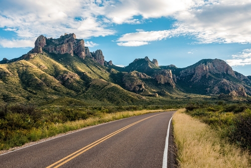
While it’s true that much of Texas is fairly flat, the western part features deserts punctuated by rocky buttes, canyons and mountain ranges topping out at nearly 8,800 feet above sea level. The state’s two national parks are located in this region, too. Guadalupe Mountains lies east of El Paso and borders New Mexico. The better-known Big Bend National Park occupies a curve along the U.S./Mexico border. This outstanding natural area has several scenic routes both inside and adjacent to the park. Ross Maxwell is the most famous drive, but there’s a lot to see before you reach its isolated location.
As the Rio Grande flows slowly from the Rocky Mountains to the Gulf of Mexico, it forms the entire border between Texas and Mexico. The “Big Bend” occurs when the southward-moving river flows north before turning south again. From river habitats to desert landscapes and imposing mountains, Big Bend is incredibly diverse. It’s also one of the few parks where summer travel is discouraged. Because it gets so hot, many services shut down. Fall, winter and spring are by far the best seasons to visit, so be sure to consider reserving a campsite. There are a few private campgrounds outside the park while inside Big Bend you’ll find four, operated by the National Park Service and its concessioner. Backcountry camping is also allowed but you’ll need a permit.
All major roads to Big Bend lead through one of three eclectic towns – Marfa, Alpine or Marathon – and it’s worth driving US 90 to see them all. Lying about 200 miles southeast of El Paso and 100 miles northwest of Big Bend National Park, Marfa sits the farthest west on US 90. From Marfa, it’s 26 miles east to Alpine and another 31 miles east to Marathon. Marfa is the best known, revered in movies and magazines as an artistic outpost in the West Texas desert. The town itself is actually more understated than you might expect with many galleries, restaurants and shops tucked away on side streets. There’s something about Marfa that’s really cool. It has an artsy vibe without being touristy or arrogant. The next town east, Alpine, is larger and features more lodging and restaurants. It’s also home to Sul Ross State University, a small school where you’ll find the Museum of the Big Bend. The western artwork, photographs, maps and Big Bend Legacy exhibit set the stage for a visit to the region. The third town, Marathon, is much smaller and offers an RV park, upscale hotel and a couple of restaurants, including the Brick Vault Brewery and Barbecue, considered by many to be a top Texas BBQ location.
There are three road trip oddities to mention, too. If you’re heading into Marfa from the El Paso area on US 90, about 37 miles west of Marfa near the town of Valentine look for Prada Marfa. Erected next to the highway in 2005, this permanent art installation mimics a tiny Prada store, right down to the authentic luxury merchandise. Then, on the east side of Marfa, almost nine miles out of town on the way to Alpine along US 67, watch for the Marfa Lights Viewing Area. On a lucky night you might spot the phenomenon which some say are UFOs or ghosts. However, scientific types think the Marfa Lights are more likely caused by vehicle headlights, atmospheric reflections or even campfires. Next, in Alpine, a two-mile roundtrip hike up Hancock Hill leads to the Sul Ross Desk. In 1979, college students carried a desk to the hilltop to study while enjoying the expansive views. One also wrote in a notebook which was left in a drawer and then added to by visitors. Today, the original desk has been replaced several times, and people still climb to the top to sit and leave their thoughts. As each notebook fills, it’s taken into town to be permanently stored at the Archives of the Big Bend. Lastly, you might have heard about another tiny store replica located along US 90 near Marathon but sadly, this mini Target, complete with shopping cart, was demolished in 2020.
There are two main ways to reach Big Bend National Park. One option is to head south on State Highway 118 from Alpine which leads to the park’s western side. However, our itinerary explores Big Bend’s eastern side before moving west. Services are limited and expensive in the park so before venturing out, make sure the fuel tank is full or the battery charged and you’ve got plenty of water and food. Then, drive south of Marathon on US 385. Just as you’re leaving town, look for turkey vultures that might be sitting on poles warming their enormous wings. From Marathon, it’s about 42 miles to the national park’s entrance station and Persimmon Gap Visitor Center.
Big Bend is surrounded by the vast Chihuahua Desert and as you follow the main road through the park, stark mountains loom on either side. Dog Canyon and Devil’s Den are popular hiking trails along this section and about 18 miles from Persimmon Gap, look for the Fossil Discovery Exhibit. It’s eight more miles to Panther Junction where you’ll find another visitor center, a gas station and the park’s headquarters.
Big Bend has three particularly pretty drives, starting with Park Route 12 which runs 20 miles to the southeast, connecting Panther Junction to Rio Grande Village. The highway descends nearly 2,000 feet to the river with fantastic views as it cuts through ancient limestone. Along the way, Dugout Wells features picnicking and a nature trail that’s popular for birding and studying cactus, cholla, ocotillo and other desert plants. Closer to the river, you can soak in hot springs that humans have enjoyed for centuries. Today, the ruins of a bathhouse built in the early 1900s hold the 105 F water before it flows into the Rio Grande. The road ends at the start of an excellent hike that follows the river and international boundary into the mouth of Boquillas Canyon. Mexico lies on the opposite riverbank. Rio Grande Village has camping, fuel and a visitor center but check beforehand as some services are closed in summer. Hiking, biking, birdwatching, fishing, stargazing and horseback riding are all popular Big Bend activities. Kayaking, canoeing and guided rafting trips on the Rio Grande are fun, too, but you’ll need a backcountry permit.
Back at Panther Junction, the second amazing scenic drive starts three miles west. From the main highway, take a left onto Chisos Basin Road. It’s a striking contrast to the Rio Grande Village route as Chisos Basin climbs more than 2,000 feet from the desert floor into the mountains. Built by the Civilian Conservation Corps in the 1930s, this awesome six-mile-long road boasts sharp curves and grades as steep as 15%. So if you’re driving an RV, check restrictions before you go. Relatively cooler temperatures, mountain peaks and oaks, junipers and pinyon pines give this area a unique vibe from the rest of Big Bend. In addition to camping and hiking, Chisos Basin has a visitor center, lodge and restaurant.
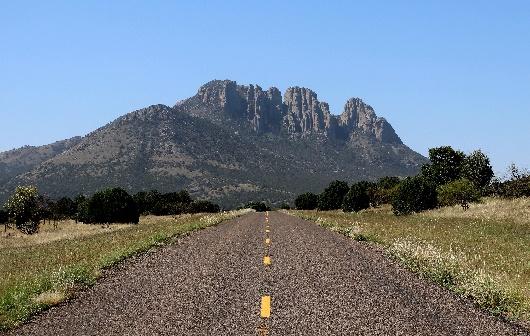
Big Bend’s third scenic drive is considered by many to be its finest. From the Chisos Basin turnoff, continue 10 miles west and then turn left onto Ross Maxwell Scenic Drive. Named after the park’s first superintendent, Ross Maxwell was a geologist who specifically designed this route to show off Big Bend’s exceptionally diverse topography. Look for one of the most prominent landforms, Mule Ears Peaks, created by ancient volcanoes and erosion. Ross Maxwell’s 31 miles wind through millions of years of geological history before ending at the Rio Grande. One of the park’s most spectacular trails follows the hillside and riverbank for about a mile into Santa Elena Canyon. Carved by the river, 1,500-foot-high limestone cliffs frame the water, with Mexico to the left and the United States to the right.
From here, you can either return on Ross Maxwell Scenic Drive or take the shorter 13-mile Old Maverick Road, well-maintained gravel that’s usually fine for most vehicles but may be impassable after heavy rains. Be sure to monitor local conditions. Back at the Ross Maxwell junction, it’s 8 miles to the park’s western entrance, where Old Maverick Road also intersects the main highway. Continue 82 miles north on State Highway 118 to Alpine. Or go four miles to Terlingua where our next scenic drive, El Camino del Rio, is featured below.
El Camino del Rio – 62 miles
From Terlingua to Presidio
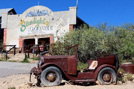
This is one of my favorite scenic drives in the U.S. El Camino del Rio, which is also referred to as River Road and FM 170, has all of the best qualities of a top road trip: history, amazing overlooks, unexpected sites, unique hikes and numerous other outdoor activities. Plus, the route follows an international boundary which just feels exotic. You can either start in Alpine and drive 84 miles south via State Highway 118 to Terlingua. Or pick up this route as you’re leaving Big Bend. The national park’s western entrance is just eight miles east of Terlingua, a dusty ghost town that’s become home to artists, retirees and outdoor enthusiasts. In addition to building ruins and an old cemetery, today this early 1900s mining settlement has art galleries, gift shops, eclectic lodging and camping, restaurants and bars. And on the first Saturday of every November it hosts thousands of “chili heads” who come for a championship chili cookoff that started in 1967. But don’t look for an organized downtown. Part of Terlingua’s appeal is its ramshackle, Old West appearance.
From Terlingua, follow FM 170 west 11 miles to the Barton Warnock Visitor Center. While Big Bend National Park lies a few miles to the southeast, the El Camino del Rio passes through the southern part of Big Bend Ranch, Texas’ largest state park. FM 170 is the only paved route into Big Bend Ranch, providing access to gravel two- and four-wheel-drive roads. Mountain biking, hiking, backpacking, horseback riding and various watersports are the main activities, and the visitor center has information, permits and licenses. Big Bend Ranch is an International Dark Sky Park so stargazing and astrophotography are incredible here, too. West Texas lies in the Chihuahua Desert, the largest desert in North America, and the visitor center has a two-acre garden where you can view and learn about native plants.
A mile down the highway from the Barton Warnock Visitor Center is Lajitas, an old Army post that’s now the Lajitas Golf Resort and Spa, with a highly regarded 18 hole championship golf course. The resort also runs the nearby Maverick Ranch RV Park. Lajitas is where the highway joins the river, and as its Spanish name implies, El Camino del Rio means “the river way.”
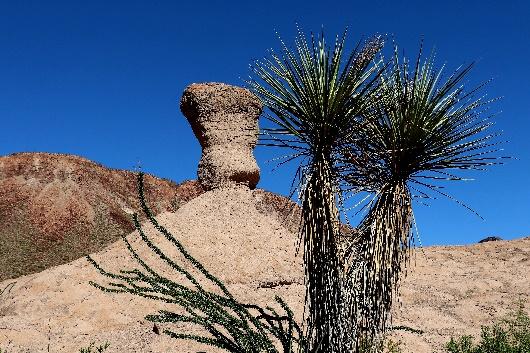
The River Road is a paved rollercoaster pitching up and down the hills and cliffsides overlooking the Rio Grande. It’s not really a rough or frightening drive but you certainly won’t get sleepy from the stimulating curves and scenery. The highway is officially marked as Farm to Market Road 170. Created by legislation in 1949, Texas’ farm to market roads are an extensive network of secondary roads connecting rural or agricultural areas to towns and cities. Sandwiched between rock and river, El Camino del Rio is one of the most picturesque drives in Texas. For 50 miles, this farm to market road parallels the Rio Grande and international border. When you’re not enjoying views of Mexico, look for hoodoos, sculptured pinnacles of weathered rock. Volcanic eruptions and lava flows created the area’s mountains while ash deposits eroded to form the hoodoos. Meanwhile, the waters of the Rio Grande carved the impressive canyon. There are pullouts, picnic areas and permit-required camping spots along the drive.
Twenty miles from Lajitas, look for the parking area for the Closed Canyon Trail, an easy 1.4-mile roundtrip hike that follows a narrow slot canyon. From Closed Canyon, it’s 4.5 miles to the Hoodoos and Balanced Rock Trail where a short trek leads to various photogenic rock formations. You can also walk along the Rio Grande with lush habitat and lower temperatures, a cool contrast to the surrounding desert.
From here, El Camino del Rio continues another 22 miles to Fort Leaton State Historic Site, where restored buildings and exhibits offer insight into border life in the 1800s. The fort also has info, permits and licenses for Big Bend Ranch State Park. It’s another three miles to the scenic drive’s end in Presidio with fuel, food and a border crossing to Mexico. From Presidio, continue 60 miles north on US 67 to Marfa. Or you can return 62 miles via the River Road to Terlingua.
Davis Mountains Loop – 135 miles
From Alpine to Fort Davis, around the loop and back to Fort Davis and onto Balmorhea State Park
No, “Texas Alps” isn’t a reference to Houston’s skyline or the Runaway Mountain ride at Six Flags Over Texas. But with peaks topping out at 8,382 feet, the Davis Mountains, aka Texas Alps, are a high altitude retreat in the stifling, unforgiving Chihuahua Desert. Located in the center of West Texas, this scenic drive is an easy day trip from Marfa or Alpine, if you’re using either town as a homebase for Big Bend. From Marfa, it’s 17 miles northeast on State Highway 21 to Fort Davis.
The prettier approach follows Highway 118 northwest from Alpine. This is also the most direct route to reach the first attraction, Chihuahuan Desert Research Institute, 21 miles from Alpine. At 5,100 feet above sea level, the institute has more than five miles of hiking trails for exploring grasslands, rock outcroppings and a canyon. Other attractions include the Desert Botanical Gardens, Maxie Templeton Cactus Museum Collection and Heritage Mining Exhibit.
From the institute, it’s five miles to Fort Davis, elevation 5,050 feet. It’s the highest town in Texas with a couple of inns and RV parks, restaurants and an ice cream shop. It has an Old West vibe and if you want to learn about frontier times through memorabilia donated by pioneer descendants, drop by the Old Overland Trail Museum. It’s open on Friday and Saturday afternoons. Fort Davis and its precursor, Chihuahua, came to be not long after the adjacent military post was founded in 1854. Today, the Fort Davis National Historic Site preserves numerous ruins and structures, including six buildings restored and furnished to the 1880s period. There are also several hiking trails. Fort Davis played a key role in the settlement and development of the American Southwest. It was a strategic post along the San Antonio – El Paso Road, a major trade route to California. Until it was shut down in 1891, the fort protected freighters, mail coaches, settlers and travelers. It was also a prominent post for Buffalo Soldiers, African American cavalry troopers who served in the American Indian Wars army.
From Fort Davis, head four miles west on Highway 118 to Davis Mountains State Park. The road follows Limpia Creek as it passes through Limpia Canyon. The most striking features are lava columns formed by volcanic activity that created the Davis Mountains some 35 million years ago. The park offers hiking, horseback riding, backpacking, birding and mountain biking. There’s camping or you can book a room at Indian Lodge, the park’s historic 39-room motel with a restaurant and swimming pool. Stargazing is also big, as it is throughout the region thanks to high elevation, clear skies and isolation from urban lights.
In fact, the next stop is world-renowned for its study of the sky. As Highway 118 leaves the state park, it winds higher into the Davis Mountains, with wide views of the surrounded peaks, valleys and desert. It’s twelve miles to the McDonald Observatory, run by the University of Texas. You may have heard the observatory’s daily astronomy radio program or magazine, both called StarDate. The Visitors Center has a theatre, science museum with interactive exhibits, café and gift shop. Guided tours of research areas along with sun viewing sessions are offered afternoons from Tuesday through Saturday. After the sun sets on Tuesdays, Fridays and Saturdays, come back for “Star Parties” when you can observe the moon, planets and galaxies through large telescopes at the Public Observatory.
From the McDonald Observatory, Highway 118 continues meandering northwest. In about nine miles, look for the Madera Canyon Trail parking area. With good birding and wildlife viewing opportunities and “no dogs allowed,” this 2.4-mile loop trail is popular with hikers and photographers.
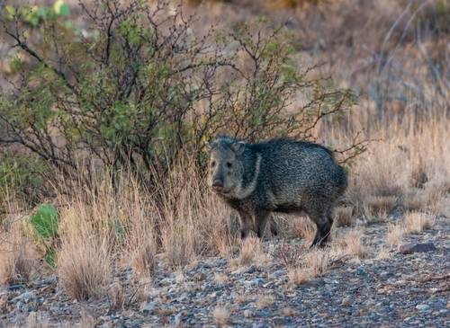
From Madera Canyon, follow Highway 118 about six miles to Highway 166 and turn left. As the loop route heads southwest, you can’t miss Sawtooth Mountain in the distance, the scenic drive’s most distinctive landform. About eight miles along Highway 166, look for another camera-friendly stone formation, Balance Rock. Watch for wildlife including pronghorn, deer and snakes sunning on the pavement. In late summer you’ll likely to see male tarantulas crossing the road in search of love. Other animals you might observe throughout the Davis Mountains include javelinas, black bears, bobcats, elk, mountain lions and all kinds of birds and lizards.
From Balance Rock, Highway 166 passes through grassland, ranchland and desert for about 35 miles as it curves south and then east toward Fort Davis. At the intersection with Highway 17, it’s 18 miles south to Marfa. Or go left and in two miles you’re in Fort Davis again where Highway 118 gets you back to Alpine. Another option is heading 39 miles northeast of Fort Davis on Highway 17 to I-10. It’s a pretty drive as the road passes through more volcanic landscape and lava columns before crossing the desert.
About 32 miles from Fort Davis on Highway 17, the highway reaches the small community of Toyahvale. If you go left onto FM 3078, it’s two miles west to Mission Mary. Now called Calera Chapel, it was built by Mexican American settlers in the early 1900s. The tiny, eye-catching church is worth a quick peek before continuing west on I-10 toward El Paso. If you go right at Toyahvale and stay on Highway 17, Balmorhea State Park will be on the right. There’s camping and motel-style lodging at the retro San Solomon Springs Courts. The main draw is swimming and scuba diving in the world’s largest spring-fed swimming pool built by the Civilian Conservation Corps in the 1930s. From the state park, it’s about seven miles to I-10 and points east including Fort Stockton and San Antonio.
Texas Hill Country – 213 miles
Following the main itinerary from the Lady Bird Johnson Wildflower Center to Fredericksburg and Medina before ending in New Braunfels. Add 88 miles for the Devil’s Backbone and 104 miles for Lost Maples/Leakey detours
Map 2: Devil’s Backbone Detour
Map 3: Lost Maples and Leakey Detour
There are plenty of reasons to visit Austin and San Antonio, two outstanding Texas cities known for their history, food and music. But just west of Austin and north of San Antonio is Texas Hill Country, a showcase of natural attractions, orchards and wineries, Lady Bird and LBJ history and German American culture. This C-shaped road trip starts in the southwestern suburbs of Austin, heads west to Fredericksburg, curves south to Medina and then returns east, ending in New Braunfels, northeast of San Antonio.
To set the mood for enjoying the region’s unique topography, stop first at the 284-acre Lady Bird Johnson Wildflower Center, 12 miles southwest of downtown Austin. Founded by the former first lady and actress Helen Hayes in 1982, it features cultivated gardens, managed natural areas and wildlands, an arboretum, Wildflower Café and Shop & Gallery.
From the Wildflower Center, make your way to US 290 and head 22.5 miles west where you’ll turn right onto FM 3232. Then, it’s six miles north to Pedernales Falls State Park. The drive west from Austin to the falls climbs the Edwards Plateau, an elevated region in central Texas. Millions of years ago, an ocean covered much of what became the state. Marine deposits created rock that was pushed up by geological forces. Erosion then formed ridges, hills and valleys. At the state park, the Pedernales River has worn big chunks of limestone into smooth channels and pools. There’s no swimming at the falls but you can sun on the rocks. Farther down the river, swimming, wading, tubing and fishing are allowed. Camping, hiking, mountain biking and horseback riding are popular, and the park also has a butterfly garden and bird blind.
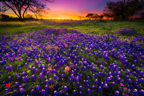
From Pedernales Falls, head 10 miles west to Johnson City. This itinerary includes a couple of impressive alternative routes. Devil’s Backbone is the first major detour which is reached by driving 14 miles south of Johnson City on US 290 and US 281 to Blanco. The small town has a couple of interesting attractions. The Buggy Barn Museum exhibits more than 250 buggies, carriages and wagons from the 1840s to 1900s. There’s also an active Old West-themed movie studio behind the museum. Nearby, Blanco State Park lies on the banks of the Blanco River. The little park has camping, swimming, fishing, paddling and picnicking. Then, two miles south of town on US 281, take a left onto FM 32 and the start of Devil’s Backbone. The curvy 23-mile route follows a limestone ridge, the “backbone,” and is said to be haunted. But don’t let the ghosts of pioneers, Native Americans and car accident victims scare you from this very scenic drive which is especially pretty in spring when Texas bluebonnets are blooming, from the end of March through late April. The Devil’s Backbone arrives in the eclectic town of Wimberley with tin-roofed restaurants, shops and galleries including Wimberley Glassworks with free glassblowing demonstrations. Wimberley Zipline offers a highflying overview of the area while Blue Hole Regional Park is a natural swimming area framed by cypress trees. From Wimberley, you can loop back to Blanco by following FM 2325 and FM 165.
Returning to the main itinerary and Johnson City, the next part of the trip is steeped in presidential history. Lyndon Johnson, the 36th president, grew up in this town that bears his family’s name. The Lyndon B. Johnson National Historical Park has two sections. The first, in Johnson City, features LBJ’s Boyhood Home and Johnson Settlement, where the president’s family originally lived. Then, drive 14 miles west on US 290 to the second and much larger section with the LBJ Ranch, a one-room schoolhouse, the Johnson Family Cemetery where LBJ and Lady Bird are buried and the “Texas White House,” the family ranch house.
Starting in Johnson City and following US 290 west to Stonewall and Fredericksburg, you’ll notice wineries, orchards and fruit stands. The region is a prime peach growing area and plums, strawberries, blackberries and all kinds of vegetables do well here, too. Texas Hill Country is also the nation’s third largest American Viticultural Area with more than 100 wineries offering tastings and, in some cases, lodging and RV parking.
From LBJ Ranch, it’s 18 miles to Fredericksburg, the hub of tourism in Hill Country with a bustling downtown that feels both western and German. The town was founded by German immigrants in 1846 which you can learn about through displays at the Pioneer Museum and Vereins Kirche Museum. If you’re staying in Fredericksburg for awhile, the 120-mile self-guided Gillespie County Country Schools Driving and Cycling Trails features 17 historic country schools dating from 1847 to 1936. Another popular attraction is the National Museum of the Pacific War which was built in Fredericksburg because native son Chester Nimitz commanded the U.S. Pacific Fleet in World War II. Seventeen miles north of town is Enchanted Rock State Natural Area where the star attraction is a lone, huge pink granite dome with hiking, rock climbing, birding, picnicking, stargazing and camping.
From Fredericksburg, wander 24 miles southwest on Highway 16 through the Guadalupe River Valley to Kerrville where the Museum of Western Art has exhibits on cowboys and ranching, Native Americans, settlers, women of the West and mountain men. History lovers might also enjoy the Schreiner Mansion which was built by German masons out of local limestone in 1879. Today, it’s listed on the National Register of Historic Places and open for tours on Thursdays.
From Kerrville, the road trip’s second major detour follows Highway 27 west to Ingram and Highway 39 through Hunt. Then, the road twists and turns as it runs southwest along the South Fork Guadalupe River. Twenty miles from Hunt, turn left onto FM 187 and go 14.5 miles to Lost Maples State Natural Area where the Sabinal River has carved sheer canyon walls out of the rugged terrain. The park protects a stand of Uvalde bigtooth maples and is particularly spectacular and popular in autumn. Photography, birding, wildlife watching, hiking, backpacking, fishing, stargazing and camping are typical activities. If motorbikes are more your thing, check out the Lone Star Motorcycle Museum, a mile from Lost Maples on FM 187. The collection includes some 60 bikes from around the world, dating from the 1910s to today. Continuing south on FM 187, in three miles turn right onto FM 337 where more gorgeous landscapes unfold as the road winds 15 miles through gorges and past cliffs to tiny Leakey. The town has fuel, a couple of restaurants and Josh’s Frio River Outfitters with gear, shuttle service and lots of souvenirs. From Leakey, return east 37 miles on FM 337 to Medina where we pick up the main itinerary.
Back in Kerrville, go 24 miles south on Highway 16 to Medina, the “Apple Capital of Texas.” Open year-round, Love Creek Orchards and The Apple Store sell baked goods, gifts and fresh seasonal apples. Highway 16 then moves southeast through ranchland to Bandera. Established by Polish settlers in the 1850s, the town figured prominently in the great Texas cattle drives of the late 1800s. Nicknamed the “Cowboy Capital of the World,” the ranch theme carries throughout the western style downtown. There’s nightly music, Saturday afternoon “gunfights,” dude ranches and the Frontier Times Museum, with fun and quirky exhibits on Texas history and cowboy culture. The dioramas at the Bandera Natural History and Art Museum highlight Texas Hill Country wildlife and their habitats while the New Spain Art Collection displays paintings, pottery and sculptures from colonial Mexico.
Following Highway 16 east to Highway 46, it’s 24 miles from Bandera to Boerne, another fascinating town with German heritage where the Cibolo Nature Center offers miles of trails through five distinct ecosystems along Cibolo Creek. On the other side of the water, there’s more hiking at Herff Farm along with community gardens and a year-round Saturday farmers market. And on hot summer days, cool off on a guided underground tour of Cascade Caverns’ five amazing rooms.
Driving east out of Boerne on Highway 46, it’s 16 miles to Guadelupe River State Park defined by steep limestone bluffs, four natural rapids and bald cypress trees lining the riverbanks. Visitors come to swim, tube, canoe and fish. There’s also camping and 13 miles of hiking and biking trails.
It’s 31 miles east on Highway 46 to New Braunfels, another charmer with BBQ, Tex-Mex, breweries, wineries, boutiques and antique stores. For kids and the young at heart, Schlitterbahn Waterpark has slides, pools and river rides. Germany’s Prince Carl of Solms founded the city in 1845 and just north of town, German-Texas architecture distinguishes the Gruene Historic District. Inside the renovated 19th century buildings are restaurants, bars, gift shops, B&Bs and the oldest dance hall in Texas. Outside of New Braunfels are two extraordinary cave experiences. Fifteen miles west of town, Natural Bridge Caverns gives guided tours of Texas’ biggest cavern. A couple of miles away is Bracken Cave, home to the world’s largest bat colony and one of the greatest concentrations of mammals on Earth. Every summer, more than 15 million Mexican free-tailed bats roost in the cave. You must make reservations to observe the tornado of hunters spiraling out for their nightly insect feast.
Canyons of the Texas Panhandle – 148 miles
From Amarillo to Palo Duro Canyon and Caprock Canyons
In the category of “unexpected,” this road trip is top of mind. It doesn’t matter where you’re driving from because the terrain around Amarillo is essentially flat for miles and miles in all directions. But 30 miles southeast of the city, the land parts into a wide crack, revealing America’s second largest canyon after the Grand Canyon: Palo Duro. From there, the scenic drive continues southeast to Caprock Canyons, another colorful gap in the Earth. This route explores the upper part of the Caprock Escarpment, a steep and rocky slope forming a natural boundary between the western High Plains and eastern North Central Plains. The escarpment essentially stretches down the middle of the Texas Panhandle for about 200 miles and Amarillo makes a good approach from the north.
With hotels, RV parks, western stores and steakhouses, Amarillo is a medium-sized city with Lone Star flair. It’s the largest city in the Texas Panhandle, about halfway between Oklahoma City and Albuquerque. Amarillo is also a stop on Historic Route 66. To reach the area’s most famous natural attraction, head south of Amarillo 17 miles on I-27 to exit 106 where you’ll then drive east on Highway 216. After 11 miles of farmland, the plains suddenly give way to an 800-foot-deep canyon that’s 120 miles long and 20 miles wide in places.
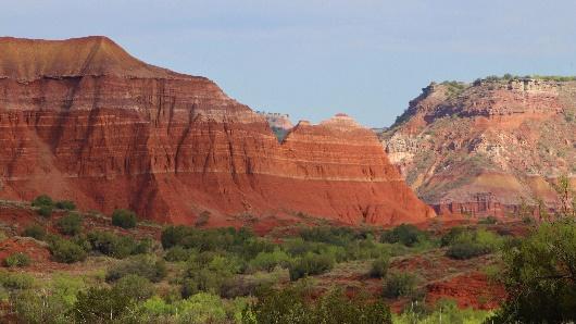
Over millions of years, water from the Prairie Dog Town Fork of the Red River along with wind, rain and snow eroded the landscape into Palo Duro Canyon. The most impressive section makes up Palo Duro Canyon State Park, where a sixteen mile paved, looping road descends to the ravine’s floor, passing through multihued layers of sedimentary rocks from four geological periods. Variations of red, orange, yellow and white color the surrounding buttes and pinnacles. Hiking, biking, horseback riding, birding and wildlife watching are the main activities. Campsites and cabins fill up early so be sure to reserve. The visitor center has archeological and nature exhibits and sells southwest art and handmade Native American items such as pottery, silver and turquoise jewelry and hunting knives. In the summer, the TEXAS Outdoor Musical is performed in the outdoor amphitheater.
From the visitor center, exit the state park and return west on Highway 217. But before reaching the freeway, turn right onto Washington Street and go north. Then take a right onto FM 1151 and drive east to Claude. It’s 45 miles from the visitor center to the small town. Then, head south on Highway 207 where soon the agricultural fields melt away for another perspective on Palo Duro Canyon. While this view isn’t as dramatic as the state park’s, it’s still quite colorful as the road descends to the bottom and crosses the Prairie Dog Town Fork of the Red River. Palo Duro means hardwood in Spanish which refers to the junipers and mesquite growing in the area.
Highway 207 then climbs out of the canyon and passes through ranchland before reaching Lake Mackenzie, 41 miles south of Claude. The reservoir has camping, a couple of cabins and a marina. Boating and fishing happen on the lake while land-based fun includes hiking, birding and driving ATV trails.
Continuing south, the highway enters Tule Canyon, another vibrant ravine with striking rock formations and roadside wildflowers. Parts of Texas are especially known for their highway blooms, and you’ll see many different kinds of spring and summer flowers all along this scenic drive.
Following Highway 207 south and then Highway 86 east, the drive reaches Silverton, 11 miles from Lake Mackenzie. The little town has fuel, an RV park, a couple of restaurants and shops. From there, follow Highway 86 east 16 miles to Quitaque, another town with similar amenities. The Comanchero Canyons Museum has exhibits on historic expeditions of the area, the importance of bison, military battles and the Comancheros, native people of northern and central New Mexico who traded with nomadic plains tribes.
Then, it’s just three miles north of Quitaque to Caprock Canyons State Park & Trailway. Similar to Palo Duro Canyon, water and wind have sculpted the Caprock Escarpment into this park’s vividly colored canyons, bluffs and stone formations. Caprock Canyons’ scenic drive leads to overlooks and trailheads. There’s camping, hiking, biking and horseback riding as well as swimming, fishing and no-wake boating on Lake Theo. Look for mule and white-tailed deer, coyotes, bobcats and pronghorn. However, you’re most likely to see members of the Texas State Bison Herd that roam freely – so keep your distance!
Southeast of the park lies the 64-mile Caprock Canyons Trailway, a rail-to-trail project that passes through ranchland and Quitaque Canyon before climbing over the Caprock Escarpment. A highlight is hiking or walking a bike or horse through Clarity Tunnel, an old railroad tunnel where as many as 500,000 Mexican free-tailed bats live from April to October before migrating south for the winter. From Quitaque, it’s 100 miles to Amarillo or 90 miles to Lubbock.