Bridger-Teton National Forest Guide
- Home
- National Forests
- Wyoming
- Bridger-Teton National Forest
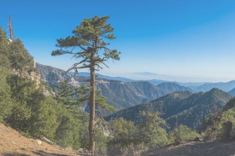
Bridger-Teton National Forest is a stunning natural haven in western Wyoming, covering over 3.4 million acres of rugged beauty. Known for its towering peaks, pristine lakes, and abundant wildlife, the forest offers endless opportunities for adventure and relaxation.
Camping in Bridger-Teton National Forest
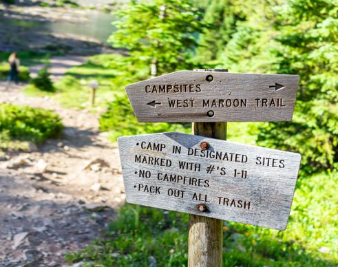
Camping in Bridger-Teton National Forest offers diverse options, from developed campgrounds with essential amenities to free dispersed areas for a secluded outdoor experience. Before you plan your trip, you can check out the top campgrounds in Wyoming.
Lakeside and Riverside Campgrounds
Granite Hot Springs Campground
Price: $20 per night
Price: $15-$30 per night
Price: Not mentioned
Price: $12 per night
Budget-Friendly Campgrounds
Price: $20 per night
Price: $20 per night
Free Dispersed Camping
Toppings Lake and Spread Creek
Shadow Mountain Dispersed Camping
Greys River Road
Group Camping Areas
Price: $35 per night
Capacity: Up to 25 people
Price: $35-$70 per night
Capacity: Not mentioned
Price: $35 per night
Capacity: Not mentioned
Fremont Lake Campground and Group Campground
Price: $50 per night
Capacity: Not mentioned
Private Campgrounds near Bridger-Teton National Forest
You can look for campgrounds in nearby towns like Jackson Hole and Alpine. Explore options for BLM camping near Bridger-Teton National Forest as well as nearby dump stations for a hassle-free experience with RVshare.
RV Rentals Near Bridger-Teton National Forest
Bridger-Teton National Forest Hiking Trails
Bridger-Teton National Forest offers a wide variety of hiking trails, from easy lakeside walks to challenging multi-day treks through the wilderness.
Lakeside and Riverside Trails
Length: 3 miles
Difficulty: Easy
Length: 7.6 miles
Difficulty: Moderate
Length: 4 miles
Difficulty: Moderate
Length: 4 miles
Difficulty: Moderate
Budget-Friendly Family Trails
Length: 2.4 miles
Difficulty: Easy
Length: 3.8 miles
Difficulty: Easy
Length: 3.5 miles
Difficulty: Easy
Advanced/Backpacking Trails
Length: 40 miles
Difficulty: Challenging
Length: 80 miles
Difficulty: Challenging
Length: 12 miles
Difficulty: Challenging
Waterfall Trails
Length: 9 miles
Difficulty: Moderate
Length: 1.5 miles
Difficulty: Easy
-
Josie's Ridge
This challenging trail leads hikers from an elevation of 6,157 to 7,700 feet. The climb is steep, but those who tackle the challenge are rewarded with stunning views of the Teton Range. In addition to forested sections and spectacular views, the trail also winds through more open landscapes dotted with sagebrush and wildflowers.
Length: 2.5 miles
Intensity: Difficult
-
Cottonwood Creek Trail
The Cottonwood Creek Trail winds through wooded hills, following the path of the sparkling creek. Hikers will be treated to diverse landscapes as they make their way along the forest path that sometimes traverses the creek bottoms before venturing further up into the forested hills. The trail crosses the creek at several locations along the way, so hikers should bring appropriate footwear for crossing the creek and exercise caution during the spring runoffs.
Length: 10.62 miles
Intensity: Moderate
-
Arrow Trail
Follow the Arrow Trail as it winds through a mixture of open meadows filled with wildflowers and thick forests filled with aspen and towering pine trees. Along the way, visitors will enjoy stunning vistas of nearby ridges and distant mountain ranges. Because this trail is designated for hikers and mountain bikers, the path is generally smooth, and creek crossings feature small log-constructed bridges.
Length: 4.5 miles
Intensity: Moderate
-
Black Canyon Trail
This trail leads hikers from the Teton Pass to the Black Canyon Overlook. The hike features moderate climbs through open meadows and along ridgelines. Hikers can glimpse views of Jackson Hole and the Gros Ventre Mountain Range from the path along the ridge to the Black Canyon Overlook. The overlook itself is the summit of Mount Elly; from there, hikers are rewarded with breathtaking vistas encompassing the Black Canyon and the Snake River Range.
Length: 6.3 miles
Intensity: Moderate
-
History Trail
Take a hike along an old wagon road that once led settlers and pioneers through Wyoming. The History path crosses through forests and open meadows, guiding visitors along a scenic path dotted with historic artifacts along the way. Look for the old tractor, the Reed Hotel Rock, and the remains of the old sawmill that once stood along the trail.
Length: 3 miles
Intensity: Moderate
-
Shoal Falls Trail
Follow this trail through a mixture of forests and wide-open meadows teeming with wildflower and sagebrush. As you hike toward the ridgeline, you'll enjoy views of the Open Door and Corner Peak. Following the ridgeline, the trail comes to the Shoal Falls overlook. You can see the falls and the upper drainage area from the overlook before descending through a path of wildflowers on your way to the creek crossing.
Length: 5 miles
Intensity: Moderate
Activities in Bridger-Teton National Forest
From thrilling adventures to serene experiences, there are various things to do in Bridger-Teton National Forest.
Winter Activities
Snowmobiling: Experience snowmobiling on groomed trails across the forest. Togwotee Pass is a popular spot for its winter scenery and varied terrain.
Skiing: Glide through scenic winter trails around Jackson Lake. Experts can enjoy Teton Pass, which is known for its demanding and rewarding terrain.
Snowshoeing: Wander at your own pace through snowy landscapes on trails like those near Granite Hot Springs.
Ice Climbing: Ice climbing on frozen waterfalls, such as those in Teton Canyon, is ideal for experienced climbers seeking a challenge.
Dog Sledding: Explore snowy trails near Jackson on a guided dog sledging tour — a fun way to experience the wilderness.
Summer Activities
Hiking: Explore various trails, from the Phelps Lake Loop to the family-friendly Taggart Lake Loop, offering stunning views and options for all skill levels.
Mountain Biking: Ride the Cache Creek Trail, featuring diverse terrain and breathtaking vistas, making it a favorite for bikers during warmer months.
Canoeing: Paddle through tranquil waters at String Lake, surrounded by awe-inspiring mountain scenery. Rentals are available nearby.
Whitewater Rafting: Embark on a guided, adrenaline-filled rafting adventure on the Snake River.
Kayaking: Glide across calm lakes like Jenny Lake, enjoying serene paddling with stunning views of the Tetons. Rentals are available from local outfitters.
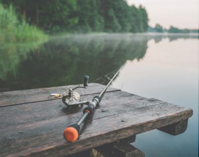
Fishing: Fish in spots like Fremont Lake and the Snake River, teeming with trout and cutthroat.
Other Recreational Activities
Wildlife Watching: Spot wildlife, like moose and elk, at Oxbow Bend and Moose-Wilson Road. Early mornings or late afternoons offer the best chances for sightings.
Granite Hot Springs: Unwind in the warm waters of Granite Hot Springs, a peaceful retreat surrounded by nature. It is perfect for hiking or skiing.
Horseback Riding: Discover scenic trails on horseback with guided tours from Teton Horseback Adventures, offering routes for all skill levels.
Stargazing: Marvel at the night sky near Shadow Mountain Campground, where minimal light pollution provides perfect conditions for stargazing.
-
Identifying Flora and Fauna

The Bridger-Teton National Forest features diverse landscapes and habitats that support abundant plant and animal life. The forest is home to large swaths of pine and aspen trees while the meadows burst with wildflowers and sagebrush. Wildlife is abundant among the forest's lush landscapes. Some of the more frequently spotted animals in the forest include bison, black bears, elk, bighorn sheep, and eagles.
-
Fishing

With thousands of lakes, rivers, and streams, Bridger-Teton National Forest offers world-class fishing opportunities. Trout is abundant in the rivers and streams of the forest. Avid fly fishers should visit the Snake River and try their hand at catching one of the native Snake River Fine-Spotted Cutthroat Trout. For those visitors who prefer fishing in colder weather, Bridger-Teton National Forest offers several options for ice fishing.
-
Geocaching

Geocaching at Bridger-Teton National Forest is allowed outside the boundaries of designated wilderness, national scenic, and historic areas. Geocaches must not disturb any of the natural landscape or any other natural resource within the forest. Geocache hunters should, instead, look for and leave their caches behind natural formations like trees or rocks.
-
Nature and Bird Watching

The Bridger-Teton National Forest offers breathtaking scenery and is home to a diverse population of wildlife. Walk the ridgelines and take in stunning vistas of the surrounding mountains and valleys. Bird lovers will want to spend some time at one of the many waterways to watch over 355 species of birds at home in the forest. Hikers often spot bighorn sheep, bison, black bears, and even moose in the backcountry. Keen-eyed visitors might even be lucky enough to spot the rare and protected trumpeter swans that call the forest home.
-
Stargazing

The Bridger-Teton National Forest offers incredible stargazing opportunities. For a clear view of the galaxy spreading out overhead, hike into the backcountry and camp under the open sky. With little light pollution from nearby communities, the sky is dark enough to showcase the breathtaking wonders of the Milky Way.
How to get to Bridger-Teton National Forest
Address: Hwy 26/287 Moran, WY 83013
Fee: Entry fee $0
By Car
From Jackson: The forest is approximately 10 miles away. Take US-191 N directly to the forest's main entry points.
From Pinedale: The drive is about 30 miles. Head south on US-191 S, which will lead you into the forest.
From Alpine: About 35 miles away, take US-89 N to connect with US-191 N, leading you into the forest.
By Air
The nearest airports to Bridger-Teton National Forest are:
Jackson Hole Airport (JAC): Located within Grand Teton National Park, it’s only 10 miles from the forest and the most convenient, offering easy access to the forest.
Idaho Falls Regional Airport (IDA): Approximately 90 miles away, this airport is ideal for travelers coming from the western states.
Seasonal Restrictions
Seasonal closures affect areas in Bridger-Teton National Forest, including Granite Creek Road and snow-covered trails like Teton Crest in spring. Summer brings heavy traffic and limited parking. For a hassle-free experience, check road conditions, trail access, and campground availability on the official website before visiting.
Fees
There is no entry fee for Bridger-Teton National Forest. However, specific sites, like Granite Hot Springs and activities like camping at designated campgrounds may incur fees. Always confirm any costs associated with particular campgrounds or recreational facilities in advance.
Frequently Asked Questions About Bridger-Teton National Forest
Is Bridger-Teton National Forest open all year round?
Yes, the Bridger-Teton National Forest is open year-round. Campers in the summer can go backpacking, fishing, boating, swimming, hiking, and biking. In winter, there is cross-country skiing, sledding, snowshoeing, and ice fishing.
What is the closest town to Bridger-Teton National Forest?
Jackson, Wyoming is one of the closest towns to the Bridger-Teton National Forest. Jackson is known for its resort amenities - you'll find upscale hotels, spas, shops, and award-winning restaurants in town. There are also activities like whitewater rafting or dogsledding that you can book in Jackson.
Can you kayak, canoe, or raft in Bridger-Teton National Forest?
Yes, you can canoe, kayak, and raft in the Bridger-Teton National Forest. The forest has plenty of mountain lakes and rivers for kayaking and canoeing. There are also several companies that lead whitewater rafting trips in the area, so you can raft with an experienced guide.
Is there a fee to get into Bridger-Teton National Forest?
No, there is no fee to get into Bridger-Teton National Forest. There may be fees required to use certain day-use areas of the forest, however. There may also be additional fees for recreational activities like camping, or boat launch fees.
What is the best time to visit Bridger-Teton National Forest?
The best time to visit Bridger-Teton National Forest is in the summer. Although there will be more crowds at that time, the forest is at its warmest so it's a great time to go hiking, swimming, and boating. Also, snow will have melted by summer, so the forest is at its most accessible as well.


