Payette National Forest Guide
- Home
- National Forests
- Idaho
- Payette National Forest
Named for an early fur trapper—Francois Payette—the Payette National Forest covers over 2.3 million acres of forests, rivers, and mountains. The forest is managed by the National Forest Service and is bordered by other federally protected areas. Though some of the lands were cultivated and settled early in its history, nearly all development projects failed. Attempts made at mining, homesteading, lumber production, and milling failed except for a few cattle grazing concerns that still use sections of the land as free-range. Within the forest are two Wilderness Areas—the Frank Church River to Nowhere Wilderness Area and the Hells Canyon Wilderness Area. While small communities like McCall, ID, and Baker City, OR, provide much of the service required to manage such a large area, Boise, ID, the nearest sizeable urban city, claims the forest as its recreation area.
RV Rentals Near Payette National Forest
Payette National Forest Hiking Trails
-
Goose Creek Falls Trail
The Goose Creek Falls Trail is an in-and-out pathway that descends to Goose Creek from a drive-up trailhead. The path is well maintained and marked with intermittent signs along the way. Though the trail is easy most of the way, the final section is a scramble over loose rocks and scree to get to the creak side.
Length: 3.1 miles
Intensity: Intermediate
-
Loon Creek Trail
Loon Creek Trail is a short pathway used by hikers, horses, bicyclists, and motorcyclists. It begins by crossing a steel bridge that spans the Secesh River, then follows Loon Creek, a tributary of the Secesh, to its entry into the river. The forests echo the babble of the creek as it flows along, giving an undeniable cooling effect.
Length: 1.6 miles
Intensity: Intermediate
-
Buckhorn Creek Trail
The Buckhorn Creek Trail is a point-to-point pathway that can be hiked either way. To walk this trail from the top, start at the summit of Rapid Peak to descend to Buckhorn Creek. Much of the upper reaches of the pathway is strewn with rocks, gravel, and boulders, making headway difficult. Once below the tree line, the pathway levels somewhat to pass through the forest.
Length: 10.7 miles
Intensity: Difficult
-
Snowslide to Lake Fork Trail
The Snowslide to Lake Fork Trail leads you to the panoramic views of the Salmon River Mountains found at Snowslide Lake. The first section of the pathway is a steep climb of as much as a 47% grade. After reaching Snowslide Lake, the path levels off for the remainder of the hike to the trailhead at Lake Fork.
Length: 11.8 miles
Intensity: Difficult
-
Granite Mountain Lookout Trail
The trail up Granite Mountain climbs 1,762 feet to the peak. The path is generally well marked and maintained. From the heights of the mountain, you get an incredible view of the Salmon River Mountains and the Seven Devils of Hells Canyon.
Length: 5.6 miles
Intensity: Intermediate to Difficult
Activities in Payette National Forest
-
Identifying Flora and Fauna

Due to the incredible elevation changes you find in Payette National Forest, there is a wide range of flora and fauna. Many visitors come to this forest specifically for that reason—to research changes caused by abrupt elevation changes. There are eight species of conifer trees in this forest, in which over 300 species of mammals and birds live, as well as several species of fish protected under the Endangered Species Act.
The Payette National Forest is home to a veritable whose who of wildlife species native to North America. Some of the 300 or more animal and bird species that call this forest home are on the Endangered Species List. The majority of species that find a habitat in this forest are more common, such as the black bear, elk, white-tailed deer, mule deer, and cougar.
-
Fishing

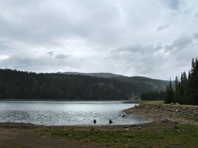
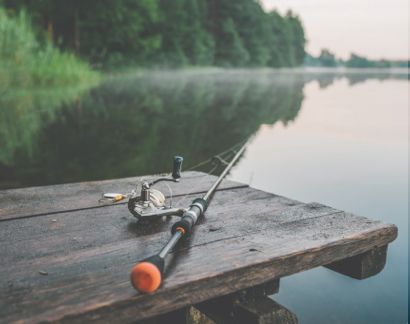
There are nearly 400 lakes in the Payette National Forest and over 4,000 miles of fish-rich streams making angling one of the main draws that bring visitors to the forest. Whether you favor dropping a fly into a small puddle along a stream or hiking to find a lake in which to fish, this forest is an angler’s dream. While the most prominent rivers—the Salmon and the Snake—provide a rich harvest of catfish and sturgeon, the smaller streams and lakes harbor fighting trout, northern pikeminnow, and mountain whitefish.
-
Geocaching

Be aware when planning on depositing a cache in this forest that wilderness areas are unavailable for the game. The remainder of the Payette National Forest not within the boundaries of the wilderness areas is available for any player to engage in the fun. To find the borders of these Wilderness Areas, stop by the Visitor Center and pick up a map with latitude and longitude designations.
-
Stargazing

Stargazing is excellent in the Payette National Forest. The high elevations and unpolluted air work together to expose a sky urban dwellers can only dream of. Those who observe the night sky from the forest realize the impact of returning to nature.
How to get to Payette National Forest
Address: 500 North Mission Street, Building 2, McCall, ID 83638
Fee: Entry fee $0
Payette National Forest is easily explored in an RV. Though many of the trails are inaccessible to vehicles, their trailheads are generally available to RV traffic. Getting around the forest in an RV gives you the peace of mind of knowing there is a comfortable spot for you to recover after hiking for miles or climbing hillsides to reach pristine lakes in which to fish. Take an RV to the Payette National Forest and enjoy your stay.
Frequently Asked Questions About Payette National Forest
Is there a fee to get into Payette National Forest?
No, there is no fee to get into Payette National Forest. However, there may be fees or permits required for various recreational activities or to use certain day-use areas and other parts of the forest.
Does Payette National Forest offer free camping sites?
Yes, there is free camping at Payette National Forest. Dispersed camping is allowed in many parts of the forest and does not cost. There are also developed campgrounds that are available to use for a small fee.
Is there a limit to how long you can camp in Payette National Forest?
Yes, there is a limit to how long you can camp in Payette National Forest. Dispersed campers may stay in the same spot for up to 14 days before needing to move.
Can you kayak, canoe, or raft in Payette National Forest?
Yes, you can kayak, canoe, and raft in the Payette National Forest. The Payette River meanders through forest lands, and there are also mountain lakes and streams that are great for paddlers.
What type of wildlife lives in Payette National Forest?
Wildlife in the Payette National Forest includes deer, elk, mountain lions, bears, coyotes, moose, mountain goats, river otters, and marmots. Birds like osprey, grouse, and a variety of others also make the forest their home.