This article is part two of our look at California. In part one, we featured the northern part of the state, which is generally best to explore in summer, fall and spring. Southern California is a little different because two routes include deserts which are extremely hot in the summer. So consider winter, spring and fall for Death Valley and Anza-Borrego. Rim of the World has both mountains and desert so spring and fall are best. Kings Canyon traverses the Sierra Nevadas making summer and fall the seasons to visit. And Route 1 follows the Pacific coastline, so it’s temperate year-round. But this drive is also extremely popular, so avoid weekends and holidays. Midweek is generally better. And all scenic drives could be impacted at any time by wildfires, smoke and staff shortages or park closures due to government funding issues.
The Top 5 Scenic Byways in Southern California include:
- Route 1 – Big Sur Coast Highway – All-American Road
- Death Valley Scenic Byway – National Scenic Byway
- Kings Canyon Scenic Byway (Kings Canyon & Sequioa National Parks)
- Rim of the World Scenic Byway
- Anza-Borrego Scenic Byway
Route 1 – Big Sur Coast Highway – All-American Road
123 miles, from Morro Bay north to Monterey
Stretching more than 1,500 miles from San Diego to Washington’s Strait of Juan de Fuca, the Pacific Coast Highway is one of the USA’s most astonishingly beautiful routes. In earlier articles we wrote about the scenic byways that parallel Northern California’s shoreline and the Oregon Coast. But arguable the best known part is the Big Sur Coast Highway that follows California Route 1 from Morro Bay to Monterey. It’s a much celebrated road trip, made famous in Hollywood films and car commercials. But these days, it takes research, planning and patience to really enjoy the drive. For one thing, its popularity means the highway can get crowded, particularly on weekends and holidays. And in the past few years, mudslides and storm damage have closed sections for long periods. But even if you’re only able to explore a few miles, the views, towns and wildlife are worth the experience.
If you drive the highway from north to south, you’ll be in the lane closest to the cliff’s edge and ocean. It also seems to be busier because Santa Cruz, San Jose and San Francisco are nearby. For this drive we’ll approach from the south, starting in Morro Bay, four hours northwest of Los Angeles. The town’s defining feature is the imposing, 576-foot-tall Morro Rock, an ancient remnant of the area’s volcanic history. Formed 23-million years ago, it rises from the ocean just offshore, connected to the mainland by a small, curving strip that forms the protected entrance to Morro Bay. The rock has been an important navigational tool for sailors for centuries, and the calm waters of the bay are popular with kayakers and stand up paddleboarders. From fishing charters and whale watching tours to romantic gondola rides and a champagne brunch cruise, there are all kinds of watercraft experiences. The small city sets a seafaring mood through its art galleries, seafood restaurants and exhibits at the Morro Bay Maritime Museum and Morro Bay Estuary Nature Center. Morro Bay State Park is large with lagoon, ocean and beach habitats. Birding, fishing and hiking are major activities. There’s also a campground, marina, golf course, café and the Museum of Natural History.
From Morro Bay heading north on Route 1, you’re now officially driving the 123-mile Big Sur Coast Highway, designated as an All-American Road, the highest honor in the National Scenic Byways program. Six miles from Morro Bay is Cayucos, where Morro Rock continues to stand out in the distance. Cayucos dates back to the 1860s when schooners plied waters that today draw surfers and stand up paddle boarders.
Continuing 20 minutes north, the highway enters funky Cambria, where a seaside psychic, vintage fashion and colorful pottery fill shop windows. But the most eclectic feature is Nitt Witt Ridge, a California Registered Historical Landmark. Starting in 1928, Art Beal spent 50 years creating his hillside dream home from car parts, beer cans, old stoves and shells as well as remnants from nearby Hearst Castle. Though it used to be open for tours, nowadays you can only snap photos of its unusual exterior.
Leaving town, the highway continues to parallel the Pacific for 23 miles as it approaches San Simeon. If there’s no mist or fog, look for Hearst Castle on the mountain ridge. On a road trip with countless jaw-dropping attractions, this 127-acre compound is probably the most famous. The 115-room mansion is certainly the most ornate! Newspaper mogul William Randolph Hearst began building his estate in 1919 and today Hearst Castle is part of the California State Parks system. It’s wise to make tour reservations well in advance.
Heading on from San Simeon, it’s five minutes to Piedras Blancas State Marine Reserve and one of the most remarkable wildlife observation areas in North America, if not the world. Along more than six miles of coastline, massive northern elephant seals leave the ocean to molt, battle, mate and give birth. It can be smelly, noisy and incredibly heartwarming to see 70-pound baby seals nurse while their moms nap, lazily flipping sand on their gigantic bodies. Thanks to their oil-rich blubber, elephant seals were hunted nearly to extinction in the late 1800s. In the early 1990s, they began settling here and before long, 25,000 had made it their oceanfront home. Named for their “only-a-mother-could-love” nose, elephant seal males weigh as much as 5,000 pounds. Living eight to ten months at sea, elephant seals come ashore twice a year. The rookery population peaks three times: January and February, early May and late October.
Nature’s spectacle continues as the road gets windier and the cliffs more steep. You never know when the fog will suddenly clear, as if it was never there at all. At Julia Pfeiffer Burns State Park, a short walk crosses under the highway and then clings to the vertical bluff. In the distance, McWay Falls plunges 80 feet to the sand and surf.
This area is also a terrific place to see California’s monster redwoods. It’s another 15 minutes to reach a roadside gem tucked away in these giants. Henry Miller was a well-known California writer who lived here in the late 1940s. Today, his house is now the Henry Miller Memorial Library, a bookstore that also hosts readings, film screenings and concerts. Red Hot Chili Peppers, the Pixies and Patti Smith are just a few of the artists who have performed on the library’s intimate stage.
A couple miles more and the road arrives in Big Sur, offering a few restaurants, stores and gas stations. While passing through, look carefully to the left for an unmarked road that curves sharply and steeply down Sycamore Canyon. It’s a tight two miles but worth the anxiety to see Pfeiffer Beach. Keyhole Arch is what most people come to see. But also look closely at the sand. Manganese garnet deposits wash down from the neighboring hills, creating purple streaks. Hence, Pfeiffer’s nickname, Purple Sand Beach. Obviously, consider what kind of vehicle you’re driving before attempting the road. The parking lot gets full quickly, too.
Back on Route 1, close by Pfeiffer Big Sur State Park has rivers running through it with outstanding hikes and campgrounds nestled among the redwoods. Growing in a strip from central California to southern Oregon, redwood forests narrowly follow the Pacific Coast, relying on the maritime climate’s moisture, fog and relatively stable temperature. Redwoods can live some 2,000 years and they’re the tallest trees in the world, reaching heights of 350 feet with trunks more than 20 feet in diameter.
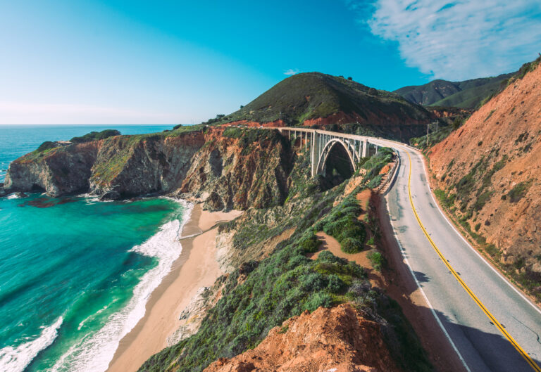
More stretches of dazzling coastline and viewpoints lie ahead before the highway eventually crosses Bixby Creek Bridge, considered the second most famous and photographed bridge in California, after San Francisco’s Golden Gate, of course. Built out of concrete in 1932, this single-span arch is 700 feet long and gracefully perches 260 feet above the beach.
It’s 11 more miles to another impressive park, Point Lobos State Natural Reserve, which is often called “The crown jewel of the California State Park System.” If you only have time for one coastal walk, jog or hike, this is the place to do it. Cliffside trails leads to tidepool treasures and pebbly beaches, making the reserve splendid for photography, painting, picnicking and scuba diving.
Route 1 now enters Carmel-by-the-Sea, a spendy town with gorgeous beaches, upscale restaurants and Pebble Beach, one of the world’s foremost golf courses. But California history is important here, too. Mission San Carlos de Borromeo is the state’s second oldest mission church, built in 1771. About 130 years later, the town was founded as an artists’ colony and seaside resort in the early 1900s.
From Carmel-by-the-Sea, it’s four miles to Monterey and the end of the scenic byway. John Steinbeck immortalized life here during the Great Depression in his book, Cannery Row. Today, the sardine canning factories have been turned into shops, restaurants and one of the world’s most respected aquatic museums. Opened in 1984, the Monterey Bay Aquarium houses more than 35,000 creatures representing over 550 species. Top exhibits include the ever-popular sea otters, Open Sea and its 90-foot observation window, a wave simulator and the artful brilliance of pulsing jellyfish. Monterey is a relaxing area to unwind with breweries, beaches and campgrounds.
Death Valley Scenic Byway
332 miles, from Death Valley Junction west to Furnace Creek, south to Badwater Basin, north to Ubehebe Crater, west to Mesquite Flat Sand Dunes, south to Wildrose Charcoal Kilns and then west to Olancha
There’s really nothing quite like Death Valley. About as big as Connecticut, it’s the largest national park in the continental U.S. And with nearly one thousand miles of paved and dirt roads, it’s smart to map an itinerary before setting out. Plus, the park’s enormous size, isolation and limited lodging options make it an ideal RV destination.
Death Valley lies in eastern California, with a small part in Nevada. Tucked in the shadows of the Panamint mountains, the park is defined by extreme contrasts, starting with elevation. At 282 feet below sea level, Badwater Basin is the lowest point in North America. Meanwhile, overlooking the valley is 14,505-foot-high Mount Whitney, the tallest peak in the contiguous U.S. On clear days from Dantes View, you can see both the highest and lowest points at the same time. In the summer, Death Valley is also the hottest place on Earth and the driest location in North America. And then there are the contrasting colors of Death Valley’s multihued landscape.
There are several ways to enter the park. Nevada is the most direct approach to Death Valley’s major attractions, following California Highway 190. From Las Vegas, it’s 93 miles west to Death Valley Junction, a speck of a settlement at the intersection of CA highways 190 and 127. A notable attraction is the Amargosa Opera House and Hotel which opened for guests in the early 1920s. Adorned with colorful murals and listed on the National Register of Historic Places, the hotel welcomes guests with 16 air conditioned rooms while the opera house hosts occasional performances. There’s also a campground.
From Death Valley Junction, head west on CA 190 and into the national park. You’re now officially driving the national scenic byway. It’s 18 miles to Furnace Creek Wash Road where a left turn, 13 more miles and several hairpin turns lead to the park’s most expansive overlook: Dantes View. A mile below, flat desert stretches north and south with the massive Panamint Range framing the panorama. From here, it’s easy to understand that Death Valley was once a shallow ocean, albeit some 250 million years ago. On a clear day, look for Mount Whitney, the highest point in the Lower 48. Staring down, you’re gazing at the continent’s lowermost point. Badwater Basin gleams bright white while swirls of color define other salt flats that punctuate the landscape. It’s worth coming at night, too, because Death Valley is an International Dark Sky Park meaning the heavens are as inspiring as the land.
Back on CA 190, continue west seven miles to Zabriskie Point. Over time, water carved canyons and channels into the yellow and brown hills. This is also a favorite spot for sunrise and sunset. From here, it’s another five miles to Furnace Creek with fuel, lodging, campgrounds, restaurants, golf and the park’s headquarters. The visitor center has exhibits, information, a bookstore and light snacks, sandwiches and water.
From Furnace Creek, you have two directions for exploring: north or south. They’re incredible so plan on both. Heading south on Badwater Road, it’s a couple of miles to Golden Canyon, where you can hike into the badlands toward Zabriskie Point. If something seems familiar, you might remember the setting from the original Star Wars. In fact, Death Valley provided the backdrop for numerous desolate desert locations in George Lucas’ early films. Just down the road is Desolation Canyon and another great trek into the eroded hills. Remember, these are fall, winter and spring activities. Here below sea level, summer temps can climb above 120 °F.
Soon, to the left you’ll see signs for Artists Drive. This short one way loop route runs south to north so explore it as you’re coming back. We’ll return to this detour in a bit. Just past the turn for Artists Drive is Devils Golf Course, where wind, rain and snow have dissolved rock salt into chunky lumps covered in sharp, jagged spires. If you hear pops and pings, that’s the crystals breaking apart as they contract and expand in the heat.
From Devils Golf Course, the park’s most extraordinary salty attraction lies five miles south. Badwater Basin sits at the base of 11,049-foot-tall Telescope Peak. A marker high above the parking area indicates how far below sea level you’ve dropped. At minus 282 feet, Badwater is the lowest point in North America. A short path leads into the snow white expanse. Stretching in every direction for nearly 200 square miles, this is the largest protected salt flat in the world. Much of the salt comes from the nearby mountains. Rain and melted snow carry minerals into the valley where crystals form as water evaporates.
Continuing south on Badwater Road and CA 178, the scenic highway pierces the southern part of the park before heading east to CA 127. It’s a gorgeous, peaceful drive and one way to exit the park.
Continuing north from Badwater Basin, it’s a quick six minutes back to Artists Drive. For nine miles, the paved one-way road winds through another harshly beautiful wonderland. World-renowned for its rocky terrain, Death Valley is an open-air museum covering much of Earth’s geological history. Artists Palette is the main highlight along this scenic detour, showcasing the park’s volcanic past when ash and cinder eruptions, and then erosion, crafted these red, orange, yellow, blue, pink and green colored hills. After reconnecting with Badwater Road, continue north to Furnace Creek and park headquarters.
Driving north of Furnace Creek on CA 190, in about 17 miles continue north on Scotty’s Castle Road. It’s 40 more miles to Ubehebe Crater, another remarkable volcanic feature that’s 600 feet deep and half a mile across. In Death Valley terms, Ubehebe is a baby, formed just 2,100 years ago or so when rising magma hit ground water, creating steam and gas explosions. Some eight miles east of the crater is Scotty’s Castle, a lavish, two-story Spanish-Mediterranean style villa built in the 1920s. It’s owned by the National Park Service but closed until further notice after flooding and a fire.
Back on CA 190 and going west, in about five miles yet another distinct geologic landform comes into view. However, this one changes with the wind. The Mesquite Flat Sand Dunes rise nearly 100 feet and formed thanks to a natural barrier: southern mountains trapping eroded particles as they blow from northern mountains. Named after mesquite, the tree thrives in the area and twists while growing to keep from being buried.
Driving farther west on CA 190, it’s 11 miles to another worthwhile side trip. A left turn onto Emigrant Canyon Road and 30 miles more, the last two on rough dirt, lead to the 25-foot high Wildrose Charcoal Kilns. The ten very photogenic beehive-shaped structures were used to provide fuel for silver and lead ore processing. Constructed in 1876, they’re thought to be some of the best-preserved charcoal kilns in the western U.S. Seven miles before the charcoal kilns is the Wildrose Campground, a first come, first served site at 4,100 feet above sea level.
Back on CA 190 driving west, the scenic byway climbs steeply as it crosses the Panamint Range. At more than 4,000 feet high, the Father Crowley Vista Point faces east, a last look over Death Valley before exiting the park. From the Mesquite Flat Sand Dunes, it’s 78 miles to Olancha and US 395.
It goes without saying to monitor fuel level, as well as the temperature gauge. With its excessive heat, vast distances and extraordinary elevation changes, Death Valley is torture on vehicles. You’ll also need to keep tabs on whether it’s suitable to drive secondary roads, due to length restrictions, weather and road conditions. Winters can be icy and summers bring flash floods. Be sure to make campground reservations as spots fill up quickly in fall, winter and spring.
Kings Canyon Scenic Byway
(Kings Canyon & Sequoia National Parks) – 142 miles, from Big Stump Entrance Station east to Copper Creek and back to Generals Highway south to Foothills Visitor Center
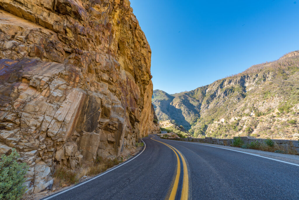
California has more national parks than any other state, and two of the nine share a border. Kings Canyon and Sequoia national parks are located in the Sierra Nevada mountains of central California, just east of Fresno. Officially, the Kings Canyon Scenic Byway follows CA 180 east into the park until the road dead ends. Because you have to backtrack, it’s more than worthwhile to follow Generals Highway south through Sequioa National Park on your return west. Note that some roads are closed in the winter and even those open all year will shut down for storms. So check conditions before you make plans.
Starting in Fresno, it’s 40 miles east on CA 180 to Sequioa National Forest and the byway’s start. As the road climbs into the mountains and Kings Canyon National Park, oak trees give way to giant sequoias. Globally, China’s dawn redwood and California’s coast redwood and giant sequoia make up the three species commonly referred to as redwoods. Giant sequoia only occur naturally at middle elevations on the western slopes of the Sierra Nevada. They are the world’s largest tree, and both the tallest giant sequoia, 316 feet high, and widest, 31.4 feet across, are found in Kings Canyon. They can also live to be really, really old, up to 3,000 years.
An interesting first stop is just past the entry fee station. Big Stump Trail winds for a mile through the remnants of an 1860 giant sequoia logging spree that ran for 30 years. Among the stumps and logs are young second-growth trees. Past Big Stump Trail, CA 180 reaches Generals Highway which heads south into Sequoia National Park. We’ll return to this intersection later.
Next, Grant Grove Village has campgrounds, horseback riding, hiking trails and the Kings Canyon Visitor Center with exhibits, a bookstore and bathrooms. The nearby General Grant Grove is a short trail through the redwoods to the General Grant Tree, the world’s second largest tree (stay tuned for the largest). The scenic byway has risen to 6,500 feet and Panoramic Point is a short, windy 2.6 mile detour east to stunning views of canyons, rivers and mountain peaks.
From Grant Grove Village, continue six miles where a right turn and three more miles lead to Hume Lake with camping, boating, fishing and lounging on the sandy beach.
Back on CA 180, the scenic byway twists and turns another 4.5 miles to one of the park’s most scenic viewpoints, Junction Overlook where two of the park’s major rivers flow together. Here you really comprehend how Kings Canyon is a park of superlatives with gigantic trees, 14,000-foot-high mountains and one of the deepest gorges in North America. Eventually, the scenic byway highway descends to the river’s edge and soon arrives at Boyden Cavern, where tours follow a paved path past stalactites and stalagmites.
From the marble cave, CA 180 wanders another 5.5 miles to water plummeting off granite cliffs at Grizzly Falls. Then, the scenic byway begins climbing again. At Cedar Grove there’s another visitor center, lodge and campgrounds. Hiking trails explore the valley named for incense cedar trees.
Back on the road, Canyon View is a can’t-miss photography spot with magnificent gorge views. The byway then comes to another waterfall parking area. Follow the half-mile roundtrip trail to Roaring River Falls where water rushes through a narrow slot and down a long rockface to a pool.
This part of the park was formed by glaciers, as you’ll notice driving through ridges of debris, called moraine. There’s also the Moraine Campground. The highway ends at Copper Creek and the start of several hiking and backpacking trails.
From the end of the road, return on CA 180 to the Generals Highway junction and go south. This 45-mile route passes from one national park into the other before arriving at Sequioa’s Foothills Visitor Center. It features more alpine panoramas and big trees as it meanders through Sequoia National Park’s western section. After leaving CA 180, it’s 13.5 miles to Lost Grove and then another three miles to Muir Grove. Both have trails through the giant sequoias with Dorst Creek Campground nearby.
Driving south seven miles brings you to Wuksachi Restaurant & Lodge followed by the Lodgepole Visitor Center with a campground and hiking trails, including one to 1,200-foot Tokopah Falls.
Two miles farther south is the park’s main highlight, the General Sherman Tree, the world’s biggest tree and one of the largest living things on Earth. If you want to learn more, go another two miles to the Giant Forest Museum. This is also the start of Crescent Meadow Road, a short romp through the forest, including Tunnel Log, a fallen giant sequoia that you can drive through. Or around if your vehicle is too big.
Back on Generals Highway, the road zigzags 15 miles past more hiking trails, campgrounds and overlooks as it descends to Foothills Visitor Center and the park’s southern entrance. It’s another 19 miles to Lemon Cove where you can head back to Fresno.
Rim of the World Scenic Byway
108 miles, from Mormon Rocks Interpretive Trail east to Mill Creek Visitor Center
If you’ve driven into Los Angeles from the north, you’ve experienced the quick and dramatic change from high altitude to sea level as roads and freeways drop from the mountains into the valleys and flatlands below, hemmed in by the Pacific Ocean to the west. The Rim of the World Scenic Byway navigates the San Bernardino Mountains northeast of LA, a welcome contrast to the beaches, palm trees, glamour and urban sprawl of America’s second largest city. Before you set out, it’s important to remember that this region experienced devastating wildfires in early 2025, and they could return at any time. So follow the news and check on attractions to make sure they’re open.
From downtown Los Angeles, it’s 63 miles northeast to Cajon Junction or 18 miles northwest if you’re coming from central San Bernardino. This junction is where I-15 meets CA 138. Go west on CA 138 about 1.5 miles to the Mormon Rocks Interpretive Trail, an easy, one-mile loop through high desert to a ridge with views of the impressive sandstone formations jutting out of the ground. You can also see Cajon Pass, an historic passage from the Mojave Desert down to the Los Angeles Basin that’s been used for thousands of years, including Mormons who traveled through in 1851. Drive another five miles east on CA 138 to the Cajon Pass Overlook for a different perspective on the box canyon.
The byway then curves south and enters San Bernardino National Forest. To the east is Silverwood Lake, a large reservoir where water enthusiasts come to boat, fish, camp and hike at Silverwood Lake State Recreation Area. It’s also a destination along the 2,650-mile Pacific Crest National Scenic Trail from Mexico to Canada. CA 138 intersects the trail before continuing another nine miles to Crestline, a small town with coffee, antique shops and Lake Gregory, another invigorating place to swim, fish, kayak and stand up paddleboard.
Just south of Crestline, CA 138 merges into CA 18. Heading east at some 6,000 feet above sea level, Rim of the World lives up to its lofty name with far-reaching views of the surrounding mountains, hills and valleys. After about seven miles on CA 18, take a short detour north on CA 173 to another shimmering blue beauty, Lake Arrowhead. The lake is privately owned and includes a resort community with lodging, dining and shopping. Adventurous fun includes biking, hiking and snow skiing as well as swimming, kayaking, water ski lessons and paddle boat tours aboard the Lake Arrowhead Queen.
Back on CA 18, drive a couple of miles east to Heaps Peak Arboretum Day Use Area where you can wander trails and photograph native plants and trees. The byway then pushes through the San Bernardino Mountains another 20 miles to Big Bear Lake, a big time tourism destination with two ski resorts, zipline tours, restaurants, breweries and accommodation ranging from campgrounds and cabins to full-service hotels. Hiking, mountain biking and all kinds of watersports on the lake are top summer and fall draws. Unique attractions include the Big Bear Alpine Zoo which treats injured, orphaned and imprinted animals. On the north side of the lake, Big Bear Discovery Center is a visitor center with exhibits, educational programs, eco-tours and outdoor concerts. Just down the road, the Big Bear Solar Observatory offers limited summer tours of its sun studying facility.
While CA 18 traverses the south side of Big Bear Lake, CA 38 follows the northern shoreline. The highways merge in the town of Big Bear, east of the lake. Continuing east on CA 38, follow the byway for 10 miles as it curves south. At Pipes Road, it’s a left turn and another three miles to Onyx Summit; at 8,443 feet, it’s the highest point along the Rim of the World. As the crow flies, the sundrenched paradise of Palm Springs lies fairly close by on the desert floor, about 8,000 feet down. It’s 75 miles to get there by road.
Onyx Summit is also the byway’s easternmost point. From here CA 38 starts a long descent, curving south and west another dozen miles to Barton Flats Visitor Center, a hub of activity for four nearby campgrounds. It’s another 18 miles downhill to the Mill Creek Visitor Center with bathrooms, gifts, maps, wilderness permits and info on the neighboring Sand to Snow National Monument. This is where the byway ends, and it’s another 16 miles west to San Bernardino.
Anza-Borrego Scenic Byway
158 miles, from the park’s western boundary east to Borrego Springs, east to Borrego Badlands, southeast to Ocotillo Wells, west to Julian and south to Ocotillo, not including numerous side trips on dirt roads
This itinerary follows some of the most scenic roads in Anza-Borrego Desert State Park, a large protected area northeast of San Diego and south of Palm Springs. In fact, it’s California’s largest state park with 500 miles of dirt roads and 12 wilderness areas. But there are plenty of paved roads, too, along with numerous hiking trails and campgrounds. Like Death Valley, Anza-Borrego is an International Dark Sky Park, meaning the nighttime skies will leave you as star-struck by the park’s beauty as its sunbathed landscapes. And though not usually as hot as Death Valley, Anza-Borrego still bakes in the summer with temps averaging above 100 °F.
About 63 miles northeast from downtown San Diego, a right turn off CA 79 leads to San Felipe Road. Follow this highway and Montezuma Valley Road east another 10 miles to Anza-Borrego Desert State Park’s western boundary. It’s another 11 miles to Borrego Springs, the park’s largest community and a logical place to start exploring. This paved route is also referred to as County Road S22, and it’s a magnificent approach to town as the highway winds through the Peninsular Range before descending to the desert basin.
You’ll reach the park’s mostly underground visitor center just before arriving in town. There are exhibits on wildlife, geology and history as well as a desert garden. A mile north is one of the park’s top campgrounds and the launch point for the Borrego Palm Canyon Trail. One of the park’s best features is its natural oases: fertile watering holes with vegetation and palms nestled in rocky ravines. The trek is about three miles there and back to see the Golden State’s third-largest oasis of California fan palms, the state’s only native palm tree species (the two largest oases are just south of Palm Springs). On the hike, look for wildlife, including the elusive bighorn sheep, “borrego” in Spanish. The park is named for bighorn sheep and Spanish explorer Juan Bautista de Anza. Borrego Palm Canyon is the park’s busiest trail so plan accordingly.
Borrego Springs offers fuel, food, camping, lodging, golfing and a diverse art scene. The Borrego Art Institute has exhibits and classes on painting, photography, pottery and gardening. Outside of town, a dragon, tortoises, camels, mammoths and wild horses are part of more than 100 giant Sky Art sculptures spread across 1,500 acres of undeveloped desert. Of course, nature’s artwork is on display everywhere, from weathered mountains and rock strewn valleys to cactus, ocotillo and desert shrubs. Anza-Borrego is renowned for its wildflowers, particularly after a wet winter. Spring comes early here and the blooms attract large crowds so keep tabs on conditions by following the park’s wildflower update page.
Borrego Springs isn’t in the state park but it’s surrounded by it. The town lies in the upper central area and if you head north, you’ll find wildflower fields and Coyote Canyon, popular with hikers, bikers and horseback riders but only navigable by 4WD. To the east of town on S22 are the Borrego Badlands, an area that was once underwater. Over time, the brackish sea receded. Millions of years of geological changes and the forces of water, rain and wind formed a crumped terrain of eroded hills and washes. For a better view, particularly at sunset, Fonts Point Road is another trail for hikers and 4WD that penetrates the badlands.
Back at the roundabout in Borrego Springs, the scenic byway follows S3 south for five miles past the Sky Art sculptures to Yaqui Pass Road. This highway travels seven miles southwest to CA 78 with more overlooks, camping and hiking. A highlight is the Cactus Loop Trail and its hundreds of succulents. Spring bloom can be really striking and it generally happens mid- to late April after the wildflowers have finished.
Alternatively, if you stay on S3 and continue driving to the southeast, you’ll pick up CA 78 in 6.5 miles. Then, it’s another 6.5 miles to Ocotillo Wells, another small community and a good place to turn around and drive west on CA 78. It’s 10.5 miles to Narrows Earth Trail, a short canyon hike focusing on Anza-Borrego’s geology. Continuing west on CA 78, it’s about five miles to Yaqui Pass Road, Cactus Loop Trail and Tamarisk Grove Campground.
Pushing further west through the hilly landscape, in seven miles CA 78 reaches Scissors Crossing which intersects both S2 and the Pacific Crest National Scenic Trail, the 2,650-mile backpacking path from Mexico to Canada. It’s worth continuing 12 miles west on CA 78 and climbing into the mountains to quaint Julian with cafes, bakeries, apple orchards, a gold mine tour and the Julian Museum and Pioneer County Park. At 4,226 feet high, it’s usually several degrees cooler here than down in the desert.
Back at Scissors Crossing, follow S2 south. Also called the Great Southern Overland Stage Route, this part of the byway follows a path with a long, dusty and rutty history. In the 1700s, the Spanish followed it. Then, in 1826 it was a Mexican mail route. Later, Gold Rush miners, Kit Carson and Mark Twain traveled the trail. In 1929 it was paved and today, it’s peppered with hiking trails, historical markers and camping. Two of the top campgrounds are Vallecito Stage Station County Park and Agua Caliente County Park, which also has hot springs.
For hikers and those with 4WD, Blair Valley Trail leads to primitive campsites and Native American pictographs. The Mountain Palm Springs Trail is a hike to a smaller and much less busy palm oasis. From Scissors Crossing, it’s 47 miles south to Ocotillo where S2 meet I-8. The Mexican border lies to the south and San Diego is 87 miles west.