The Beaver State has numerous stellar scenic byways, as detailed in our “Top 5 Scenic Byways in Oregon” article. The collection’s all-star is the Pacific Coast Scenic Byway, an All-American Road. Traveling Oregon’s coast is a bucket list experience for many, but if you don’t have time to drive the entire route, several highways cut east to west through the coastal mountains, connecting the Pacific Ocean to inland cities and the I-5 corridor.
Pacific Coast Scenic Byway
382 miles, from Astoria and the Columbia River to the California state line
From Portland, it’s 90 miles northwest to Astoria, a large town on the Columbia River with coffee shops, art galleries and the 125-foot-tall Astoria Column. Perched on a hill overlooking the city, the tower offers sweeping views of distant mountains, the Columbia as it flows into the Pacific and the Astoria-Megler Bridge, which crosses the river to Washington. The Columbia River Maritime Museum has nautical artifacts, a large collection of marine vessels and ocean-themed artwork, setting the mood for the journey ahead.
Most of the byway follows US 101 south, so start by heading out of Astoria on the highway and then follow East Harbor Drive west where Fort Stevens State Park juts into the water. With the Columbia River on one side and the Pacific Ocean on the other, the dramatic and strategic location functioned as a military fort from the Civil War to World War II. The 4,300-acre park is one of the country’s largest public campgrounds with beaches, biking and hiking trails, wildlife viewing, birding, swimming, disc golf, a military museum and shipwreck.
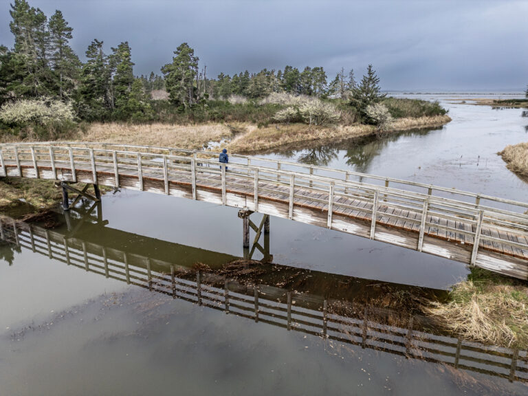
Along the byway there are dozens of parks, scenic viewpoints and recreation areas so you’re never far from a beach, hiking trail or campsite. From Fort Stevens, it’s eight miles to Lewis and Clark National Historical Park where the famous explorers and their team, the Corps of Discovery, camped during the winter of 1805–1806. The park has a visitor center with interpretive displays and a replica fort. It’s a large area on the Lewis and Clark River with hiking, paddling and fishing but no camping. From the visitor center, you can walk the 6.5 mile Fort to Sea Trail, the route Lewis and Clark traveled to the Pacific, now part of Sunset Beach State Recreation Site. Driving, it’s 7.5 miles to the site.
From Sunset Beach, continue south on US 101 for 8.5 miles to Seaside, one of the byway’s many fun, relaxing and touristy beach towns with candy shops, seafood restaurants, oceanfront lodging and an aquarium. Seaside lies north of Ecola State Park, consistently picked as a top state park by national travel and outdoor recreation publications. With nine miles of coastline, there are a lot of beaches, tidepools, forests and hiking trails to explore. Surfing is popular, too. Ecola is famous for its dramatic ocean views, including the Tillamook Rock Lighthouse, sitting on a rock more than a mile offshore. Now deactivated, “Terrible Tilly” operated from 1881 to 1957.
Cannon Beach is the next nifty beach town with the oft-photographed Haystack Rock just offshore. Moving south, Oswald West State Park has excellent hiking through rainforest, a secluded beach and some of Oregon’s best surfing. US 101 then heads southward four miles to the town of Manzanita with a few shops, restaurants and beach access. The town is also the start of the Arts Trail, running 70 miles from Manzanita to Neskowin with galleries, events, classes and performance venues.
To the south, Nehalem Bay State Park lies on a four-mile sand spit where the Nehalem River enters the Pacific. Crabbing, clamming and fishing are top activities along with camping, kayaking, birding and beach fun. Then, the byway passes by another stretch of noteworthy sandy beach at Manhattan Beach State Recreation Site before moving onto Garibaldi where the exhibits and artifacts at the Garibaldi Maritime Museum primarily focus on 18th century Pacific Northwest nautical history. Garibaldi also has a depot for the Oregon Coast Scenic Railroad with summer excursions and themed train rides pulled by steam or vintage diesel locomotives.
From Garibaldi, US 101 heads south 10 miles and inland to the farming town of Tillamook where the Tillamook County Pioneer Museum shines a light on the history of the North Oregon Coast. South of town, the Tillamook Air Museum houses restored vintage aircraft and rare wartime and aviation artifacts in a World War II blimp hangar. While driving around town and the countryside, look for quilt blocks mounted on barns and businesses. The Tillamook Quilt Trail is a self-guided driving tour featuring more than 100 of the welcoming artworks. However, the town’s main claim to fame is cheese. In 1909 several small local creameries contributed ten dollars each to start a cooperative that’s grown into Tillamook Creamery. Today, it’s one of the best known dairy product companies in the western U.S. The flagship facility offers tours, cheesy foods, an ice cream counter and farm store.
The byway then veers away from US 101 and heads back to the coast. From Tillamook, it’s 10 miles to Cape Meares
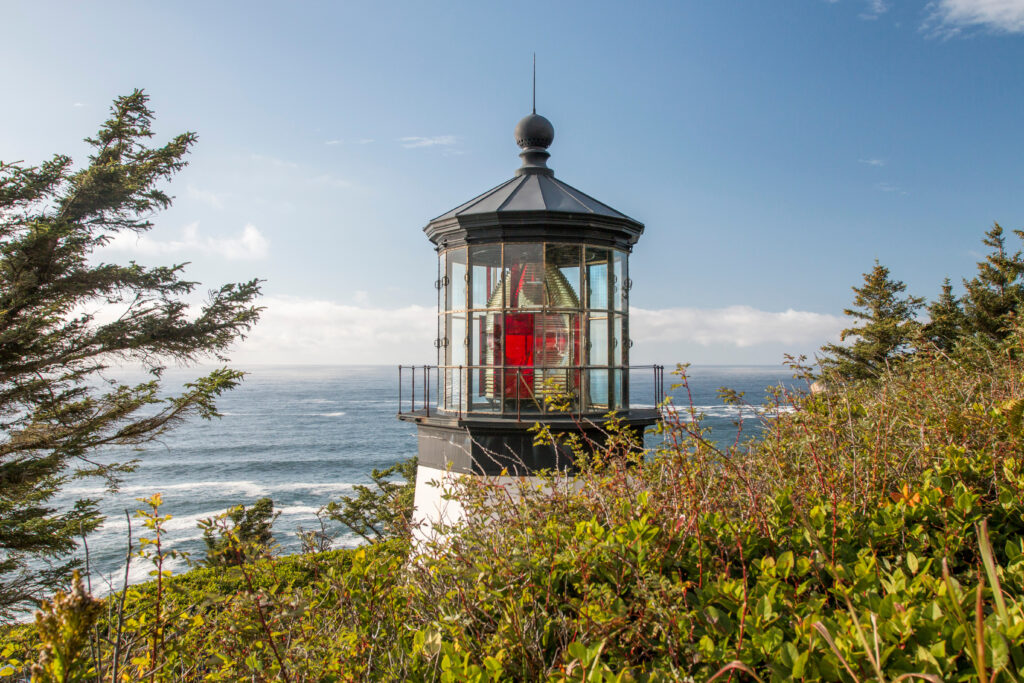
State Scenic Viewpoint where a short hike leads past a famous octopus-shaped Sitka spruce to a lighthouse that’s open for tours. But the real showstopper is the spinetingling cliffside view of the Pacific, offering gray whale spotting opportunities during seasonal migrations. Thousands of seabirds also nest in the cliffs and offshore rocks. Just south of Cape Meares, look to the sea for Three Arch Rocks National Wildlife Refuge, a group of small islands with bird colonies and sea lions.
Oceanside and Netarts are two more quaint beach towns you’ll pass through on the way to hiking, beachcombing and camping at Cape Lookout State Park. The road trip then pushes 13 miles south to Cape Kiwanda State Natural Area where instead of a sandy beach, you can climb a sandstone headland to see how the colorful cliffs continue to be sculpted by the violent waves.
From Cape Kiwanda, the byway rejoins US 101 and passes through Neskowin before reaching Cascade Head Preserve, a grassy coastal headland with rare plants and wildlife and more trails with amazing Pacific overviews.
The Sitka Center for Art and Ecology is here, too, offering workshops and events. It marks the end of the Arts Trail, which started in Manzanita.
It’s another nine miles to Lincoln City, a fair-sized town with fuel and groceries as well as seafood and beachfront lodging. As you cruise south on US 101, more scenic viewpoints, beaches and recreation areas line up back-to-back. Beverly Beach State Park has one of Oregon’s largest and most beloved campgrounds so make summer reservations early. From Lincoln City, it’s 23 miles to Yaquina Head Outstanding Natural Area which sticks out into the ocean with the majestic Yaquina Head Lighthouse anchoring the tip. Built in 1872, it’s Oregon’s tallest lighthouse and offers tours where you can climb to the top. The natural part of the area is pretty fantastic, too, with tidepools, birding and whale watching. Harbor seals are also common.
It’s just a couple of miles farther south to Newport, another attractive, bustling town that calls itself the “Dungeness Crab Capital Of The World.” Sea life gets top billing here, from serving crab and fish in restaurants to buying smoked oysters and steamer clams at a local producer like Oregon Oyster Farms. The Historic Bayfront is home port for the commercial fishing fleet as well as shops, galleries and sea lions who haul-out on the wooden docks. Newport also has two premier educational attractions. The Oregon Coast Aquarium is one of the state’s top visitor magnets with seal, sea lion and sea otter habitats, touch pools and underwater walkways through a large fish, shark and kelp-filled exhibit mimicking the Pacific Ocean. Next door, the Hatfield Marine Science Visitor Center is one of 22 Coastal Ecosystem Learning Centers in the U.S. with live animals, displays and lectures on marine and coastal environments. If you’re inspired to get on the water, several companies offer kayak tours, fishing charters and whale watching and marine life cruises. Newport has all kinds of lodging and camping, including South Beach State Park with more yurts than any Oregon state park.
From South Beach, it’s 7.5 miles to another notable state park. Instead of the beach, Brian Booth – Beaver Creek is about paddling through marshes and hiking around upland forest. The diverse landscape supports river otter, beaver, elk, deer, coyote, black bear, cougar and all kinds of birds. The marsh is an important habitat for Coho salmon, cutthroat trout and winter steelhead.
Back on the coast, it’s 16 miles from Brian Booth to Smelt Sands State Recreation Site, where anglers enjoy rock fishing and the yearly smelt run. But it’s also great for whale watching, tidepools and sunsets. Then, as you enter Siuslaw National Forest, the highway climbs to its highest point along the Oregon Coast. The Cape Perpetua Scenic Area rises 800 feet above the Pacific. Along with sensational views, a campground and visitor center, there’s a 26-mile trail system for investigating the surrounding rainforest and shoreline.
From Cape Perpetua, continue south along the sea for 12 miles to Heceta Head Lighthouse State Scenic Viewpoint, another one of Oregon’s iconic coastal beacons. You can book a stay in the assistant lightkeeper’s house or camp at nearby Carl G. Washburne Memorial State Park.
Just down the highway from the lighthouse is the touristy but fascinating Sea Lion Caves where an elevator descends into a 12-story-high, football-field-wide cave. Hundreds of Steller sea lions live here, coming and going as they please. Call ahead to check on the noisy mammals as there’s better viewing in the winter. During spring breeding and birthing time, the sea lions move to rock ledges in front of the cave and stay there through summer.
Next, go six miles south where US 101 curves inland to another intriguing natural attraction. Darlingtonia State Natural Site is an 18-acre botanical park dedicated to the insect-eating cobra lily, a type of pitcher plant that you can observe and photograph from a boardwalk trail through the wetland.
Florence is the next significant destination with a gorgeous bridge, riverfront boardwalk and historic downtown. Founded in 1909 as a river port where the Siuslaw River enters the Pacific, present-day Florence has long been a desirable and strategic location for the Siuslaw tribe and then European explorers and traders. Over time, fishing, canning, lumber, rock quarries and tourism evolved as important industries.
Many visitors come for the sand dunes, which extend some 40 miles south of town and are protected by the 31,500-acre Oregon Dunes National Recreation Area. Riding OHVs, sandboarding, sand sledding and sand camping are some of the more unusual activities. But the dunes also feature forests, lakes, wetlands and beaches so hiking, biking, horseback riding, fishing and paddling are tops, too. There are two state parks on either side of the national recreation area to consider, too. Just outside Florence, Honeyman has Oregon’s second largest state park campground and two freshwater lakes. On the south side, Umpqua Lighthouse State Park lies on Lake Marie with a small campground, cabins and yurts, and the namesake lighthouse has tours.
There are more dunes, campgrounds and parks as US 101 moves southward to North Bend and Coos Bay, neighboring towns with plenty of food, lodging and cultural options such as the Coos Art Museum, Coos History Museum and Oregon Coast Historic Railway Museum.
From North Bend, leave US 101 and drive west toward the ocean. It’s nine miles to the Charleston Marine Life Center. The exhibits, artifacts, touch pools and aquariums are developed and managed by the University of Oregon’s Institute of Marine Biology. Next, follow State Highway 540 to a trio of spectacular state parks: Sunset Bay, Shore Acres and Cape Arago. On a byway with an endless stream of beautiful vistas, these neighboring parks pack a lot of beauty and diversity into a few short miles. Framed by tree-covered cliffs, circular-shaped Sunset Bay State Park features calm waters, a white sand beach and camping. Down the road, Shore Acres State Park has high cliffs, ferocious waves, a gorgeous beach and a formal garden. The Friends of Shore Acres keeps a bloom schedule and info on the holiday light display. At the end of Highway 540, Cape Arago State Park is known for hiking, tidepools, whale watching and viewing offshore colonies of seals and sea lions. As an alternative to driving, the eight-mile out-and-back Sunset Bay to Cape Arago Trail connects the three parks.
From Sunset Bay, it’s 24 miles to Bandon, a small community with an Old Town shopping district, restaurants, golf courses, beaches, a state park and a wildlife refuge beloved by birders. While Tillamook to the north is famous for its cheese, Bandon down south is all about cranberries. Moving along the Pacific Coast Scenic Byway and US 101, look for cranberry bogs. The area is also synonymous with myrtlewood carvings, a native hardwood only found in coastal forests of southern Oregon and Northern California.
Soon, another state park beckons, 25 miles from Bandon. Cape Blanco is the westernmost point in Oregon with another lighthouse to tour, camping, cabins, horseback riding, hiking and inspirational ocean panoramas. Ten miles down the coast you’ll reach Port Orford Heads State Park, which is notable for the Port Orford Lifeboat Station, a museum dedicated to the U.S. Coast Guard surfmen who lived there from 1934 to the 1960s. When a ship was in distress, they risked their lives to help.
Back on US 101, in six short miles the byway climbs steeply to Humbug Mountain State Park. If you like to hike, a trail goes from the campground to the beach while another climbs the summit of 1,765-foot Humbug Mountain. It’s a quieter byway now as the road passes through lesser-visited terrain on the 22 miles to Gold Beach. The town sits at the mouth of the Rogue River, one of the original eight Wild and Scenic Rivers designated by the federal government in 1968. The Rogue is famous for its salmon and steelhead fishing and whitewater, and jet boat tours go up the river from Gold Beach. The town also has a brewery, coffee and seafood.
The byway concludes with a stunning finale as it winds through two state scenic corridors. From Gold Beach, it’s six miles to the Sitka spruce, walking trails and Pacific views found at Cape Sebastian State Scenic Corridor.
Then, the drive climbs cliffs and passes through forest as it follows the steep coastline of the Samuel H. Boardman State Scenic Corridor. There are numerous picnic areas, trailheads and viewpoints. Don’t miss the impressive natural rock formation just offshore at Arch Rock Viewpoint. A mile later, seven arch rocks and blowholes can be seen at Natural Bridges. Soon, the byway rolls into Brookings with all the modern conveniences before it officially ends in six miles at the California state line.