Oregon is a state of impressive contrasts, making it a stellar road trip destination. To the west, US 101 parallels Oregon’s entire Pacific Coast, giving it one of the longest and most accessible beachfronts in North America. In fact, it’s so jampacked with things to see that we’ve created a separate article on the Pacific Coast Scenic Byway. Not far from the ocean, the Cascade Range also runs the length of the state, offering plentiful mountain scenery and year-round alpine activities in Oregon’s midsection. The Columbia River runs along the to,p and in the east, there’s Hells Canyon and more mountains and national forests. If you’re looking to get away from it all, connect with nature and enjoy some of the world’s best food products, the Beaver State should be a top consideration.
- Historic Columbia River Highway – All-American Road
- Mt. Hood Scenic Byway – National Scenic Byway
- Hells Canyon Scenic Byway – All-American Road
- West Cascades Scenic Byway – National Scenic Byway
- Volcanic Legacy Scenic Byway – All-American Road
Historic Columbia River Highway
102 miles, from Troutdale, Oregon to Maryhill, Washington
The Columbia River starts in British Columbia and then rolls through central Washington before flowing across northern Oregon and into the Pacific Ocean. It’s one of the world’s great rivers, and Oregon and Washington provide excellent access. In fact, roads run along both banks as the Columbia forms the border between the two states. It’s about 310 miles following the entire Oregon route, but the prettiest section runs some 90 miles from the Portland suburbs east into the Columbia River Gorge. It’s the same path busy I-84 takes, but some parts of the original US 30 still exist, making up the Historic Columbia River Highway an All-American Road. There are a few bridges over the river, too, so you can cross back and forth between the states.
Beginning in downtown Portland, follow I-84 east for 15 miles to exit 18 and the start of the Historic Columbia River Highway. This is also the western boundary of the Columbia River Gorge National Scenic Area, which runs the length of the byway as the canyon cuts through the Cascade Range. There are two popular recreation areas here, both along the Sandy River which flows into the Columbia River to the north. The Lewis and Clark State Recreation Site has a park, boat launch and swimming area. Three miles down the road is the Dabney State Recreation Area with swimming, boating, fishing, and a beach. There’s also a first-rate 18-hole disc golf course considered to be one of the most technical and challenging courses in the Pacific Northwest.
From Dabney, it’s five miles east to the Portland Women’s Forum State Scenic Viewpoint, named for the organization that donated the overlook and worked to preserve the area’s natural beauty. The Columbia River spreads wide below, framed by forested bluffs. As it has for millions of years, the river continues to carve the 80-mile-long gorge that’s up to 4,000 feet deep. Catastrophic flooding at the end of the last Ice Age made significant cuts to the canyon, too. From the viewpoint, you can clearly see Vista House perched on the cliff’s edge 693 feet above the river.
For a closer look at the octagon-shaped beauty, drive another mile east. Nicknamed “The King of Roads,” the Historic Columbia River Highway was built in 1918. That same year, Vista House opened as a rest stop and overlook atop a rocky promontory named Crown Point. Today, Vista House is listed on the National Register of Historic Places and also features a gift shop, museum, and memorial to those who traveled the Oregon Trail. Like today’s modern highway, the historic route followed the Columbia River in its final push west.
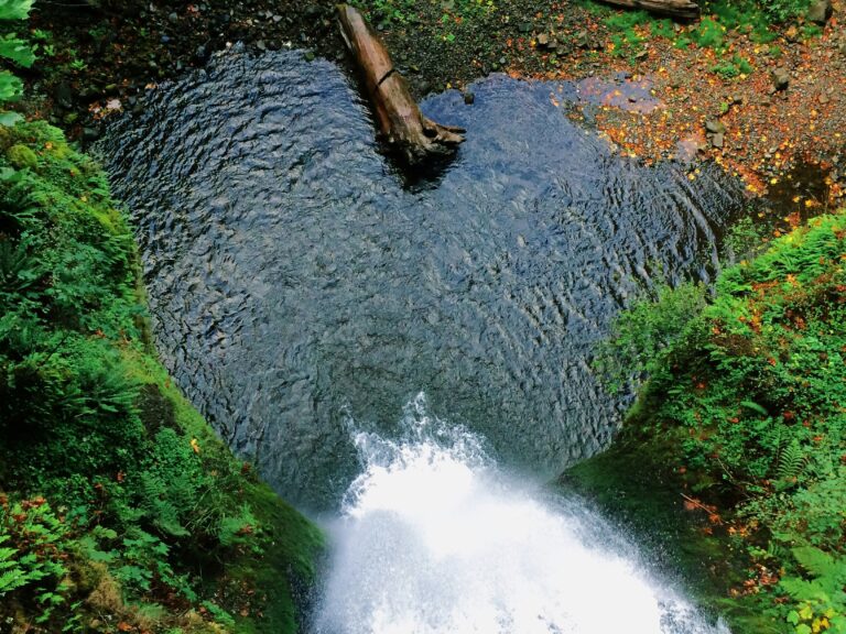
Crown Point is also the start of the “Waterfall Corridor,” starring eight of the natural wonders. Palisade Falls is the first, just around the bend from Vista House. The byway then meanders into Guy W. Talbot – Latourell Falls Trailhead State Park with hiking and picnicking. The highlight is a short walk to Lower Latourell Falls, where Latourell Creek tumbles 224 feet over walls of columnar basalt on its way to the Columbia River.
Continuing east another six miles, look for Shepperd’s Dell Falls and Bridal Veil Falls before arriving at the byway’s highest and Oregon’s most famous waterfall: Multnomah Falls. Underground springs provide a constant water supply, and its 620-foot drop makes Multnomah Falls one of the tallest year-round waterfalls in the U.S. It’s also the Pacific Northwest’s most visited natural recreation site, and so reservations are required from late May through early September, 9 a.m. to 6 p.m. Rock fans also appreciate Multnomah Falls’ 400,000 years of geological history, where the cliff face showcases six volcanic flows of Grande Ronde Basalt, exposed some 14,000 years ago by the Ice Age floods. More waterfalls lie along nearby hiking trails, and although there’s no camping or accommodations, Multnomah Falls Lodge has a visitor center, restaurant, snack bar, and gift shop.
The byway then crosses the Oneonta Gorge, a high and narrow slot canyon where moss, lichens, and ferns thrive in the cool, misty conditions. There are several trails and waterfalls in the area, including Oneonta Falls, Horsetail Falls, Ponytail Falls, and the Rock of Ages Arch. However, wildfires past and present have damaged many of the trails, so monitor Ready, Set, Gorge! for the latest updates on closures and current conditions.
The Historic Columbia River Highway then briefly merges with I-84 as it heads another eight miles east to Bonneville Lock & Dam. Completed in 1938 and expanded and updated over the years, it provides hydroelectric power while also serving as one of seven locks on the 465-mile Columbia-Snake River Inland Waterway. With two year-round visitor centers, one in each state, and a third open seasonally at the navigation lock, there’s a lot to see, including exhibits, views of the gorge from the river, and the lock in action as boats pass upstream to downstream. The fish ladder is another top draw for tourists and salmon. During high season, August to November, as many as 250,000 Chinook, sockeye, coho, and steelhead pass through the ladder in a single day.
From Bonneville, go five miles east to the town of Cascade Locks with campgrounds, coffee, restaurants, and craft beer. The Cascade Locks Historical Museum gives a solid introduction to the town and includes an outdoor display of the Oregon Pony. In 1862, it became the first steam locomotive to operate in the Pacific Northwest. Cascade Locks Marine Park lies on Thunder Island with great views and river access. The wide pool of water and windy conditions behind the Bonneville Dam creates world class conditions for sailboats and windsurfers. Fishing and biking are popular, too. Marine Park is also home port for The Sternwheeler, a replica of Columbia River vessels from the 1850s. Decked out in red, white, and blue with a 17-foot paddlewheel, The Sternwheeler has offered brunch and dinner cruises since 1983. And no matter where you are in town, The Bridge of the Gods dominates the view while providing access to Washington’s side of the river.
The next major town is Hood River, 20 miles east on I-84. On the Oregon side, the busy four-lane freeway passes by several more state parks with hiking trails and waterfalls. If you prefer the two-lane experience, pay the toll and cross the Bridge of the Gods to Washington and State Highway 14. From Cascade Locks, it’s three miles to Stevenson with tacos, a brewery, riverside cabins, and the Columbia Gorge Museum, a modern structure with rotating exhibits and permanent installations on the area’s cultural and natural history. Highway 14 is also called the Lewis and Clark Trail Highway, and you’re driving past the same ridges, cliffs, and rock spires that impressed the explorers back in 1805. Native Americans have been living, fishing, and traveling through the gorge for centuries.
From Stevenson, it’s 24 miles east to Hood River, where another bridge leads to this tourism-friendly Oregon town with art galleries, sushi, outdoor outfitters, and nearby fruit orchards, wineries, and lavender farms. The Mount Hood Railroad chugs south through the Hood River Valley with spring, summer and fall tours as well as holiday-themed rides. Hood River is also the start of the Mt. Hood Scenic Byway, which loops south around Oregon’s tallest mountain, as profiled below.
From Hood River, the byway follows I-84 on the Oregon side another six miles east to Mosier, where US 30 leaves the freeway and heads into farmland. After navigating the Rowena Curves to the top of Rowena Crest Viewpoint and more superb gorge panoramas, the byway soon reaches Mayer State Park. The riverside location has swimming, picnicking, boating, and windsurfing.
Continue east on US 30 for five miles to reach the Columbia Gorge Discovery Center & Museum, another worthwhile educational stop with permanent collections and special exhibits on the area’s human and geological history. The byway then officially ends in The Dalles, once a Native American gathering place and now a good-sized town with fuel, groceries, camping, bakeries, wine tasting, and photo-worthy murals in downtown.
From The Dalles, go about 8.5 miles, crossing the bridge into Washington, to Columbia Hills Historical State Park for camping, fishing, and biking. The park is also known for its Native American pictographs and petroglyphs. One display is self-guided, and the other requires a reserved tour.
Down Highway 14 another 12 miles east, the Maryhill Museum of Art has a collection of materials made by various Indigenous peoples of North America. Works from the Columbia River Plateau, Alaska, and California are particularly noteworthy. The ranch house turned worldclass gallery also includes European and American paintings, sculpture, decorative arts, furniture, and even chess sets.
You’re now at the eastern end of the Columbia River Gorge National Scenic Area. The nearby Maryhill Winery is a fitting way to wrap up the road trip. There’s a bistro, wine tasting, and a terrace with broad views of the surrounding vineyards, plateaus, river, and gorge.
Mount Hood Scenic Byway
87 miles, from Sandy to Hood River
This National Scenic Byway starts in the same part of the Portland suburbs as the Historic Columbia River Highway (see above) and then curves around the southern part of Mount Hood before connecting with the Columbia River byway in Hood River.
At 11,245 feet, Mount Hood is the highest peak in Oregon and the fourth highest in the Cascade Range. And like the three other volcanos that are taller – Mount Rainier, Mount Shasta, and Mount Adams – the snowcapped, triangular-shaped Mount Hood dominates its surroundings. The mountain is also frequently pictured as a backdrop to downtown Portland, making its close proximity a worthwhile daytrip.
Starting in Portland, make your way east to Troutdale and Gresham, and then follow US 26 past berry farms, orchards, and nurseries to Sandy. A mile north of town, the Jonsrud Viewpoint is considered to have the region’s best views of Mount Hood. And with a growing network of trails on federal lands, the Sandy Ridge Trail System is popular with mountain bikers.
Back on US 26, the highway moves into a beautiful forested valley as it continues 15 miles east to Mount Hood Village. Situated along the Salmon River, the Wildwood Recreation Site has fishing, swimming, hiking, and boardwalks. The Cascade Streamwatch Trail is a short paved loop with educational displays and a fish viewing window. There are several campgrounds in the area and the Mount Hood Oregon Resort has lodging, restaurants, a spa and golfing.
As you climb higher and deeper into Mount Hood National Forest, there are many options for hiking, camping, and other sports. Bustling Government Camp has lodges, restaurants, outdoor outfitters and the Mount Hood Cultural Center & Museum with exhibits on natural history, early pioneers and skiing. With 12 glaciers and annual snowfall averaging between 430-550 inches, Mount Hood supports five ski areas. The Mt. Hood Skibowl is the closest to Government Camp and also runs a summer Adventure Park with a multitude of activities including a zipline, freefall bungee jump, alpine slide, disc golf, and go-karts. Also nearby is Timberline, boasting North America’s longest ski season, from October to August. In the summer, there’s also hiking, mountain biking, and riding the Magic Mile Chair Lift for spinetingling views. The six-mile drive from Government Camp to the ski area has breathtaking overlooks and ends at the Timberline Lodge. Built in 1937 as a grand stone-and-timber mountain retreat complimenting its magnificent natural surroundings, Timberline became a National Historic Landmark in 1977. Before (or maybe after!) you visit or stay here, consider watching the famous horror film The Shining, with Jack Nicholson and Shelley Duvall. Timberline was used as the exterior for the film’s Overlook Hotel.
From Timberline, go back to US 26 and drive east. The byway then follows Highway 35 over Barlow Pass, where settlers on the Oregon Trail crossed the Cascade Range in the mid-1800s. Today, the pass is intersected by the 2,650-mile Pacific Crest National Scenic Trail as it meanders through the mountains from Canada to Mexico.
As Highway 35 turns north, it passes White River Sno-Park, popular in winter for its ungroomed backcountry ski trails. There’s more downhill skiing and warm-weather fun at nearby Mt. Hood Meadows. The resort also has summer RV parking. There are numerous hiking trails in the area, including an easy one-mile roundtrip walk to the lovely Sahalie Falls.
The byway passes more trailheads and waterfalls as it descends into the Mount Hood River Valley, a prime fruit and berry growing area. A detour on the Hood River Fruit Loop will take you to more than two dozen produce stands, wineries, breweries, and cideries. But even staying on Highway 35 puts you near agribusinesses such as Kiyokawa Family Orchards, Glacier View Lavender, Draper Girls Country Farm and Stave & Stone Winery, as the byway continues north from Parkdale to Hood River. At The Fruit Company, you can walk the orchards and tour its state-of-the-art factory. And if you’re tired of driving, the Mount Hood Railroad runs scenic trips along an old fruit packing freight line.
From Parkdale, it’s 16 miles north on Highway 35 to the byway’s end in Hood River, an attractive town overlooking the Columbia River with fuel, groceries, campgrounds, and restaurants. This is where you pick up the Historic Columbia River Highway, heading west to Portland or east to The Dalles, as profiled in our early story.
Hells Canyon Scenic Byway
276 miles, from La Grande to Baker City, including side trip to Hells Canyon Dam
Located in the far northeast corner of Oregon, Hells Canyon Scenic Byway leads to North America’s deepest canyon. Though remote, the All-American Road is easy to reach. From Portland, it’s 260 miles east on I-84 to La Grande, where the byway loops up and around the Wallowa Mountains and Eagle Cap Wilderness before returning to the freeway in Baker City. Then it’s another 128 miles east on I-84 to Boise, Idaho.
After filling the fuel tank, getting groceries, and perhaps spending the night in good-sized La Grande, begin driving Highway 82 north. The byway travels 20 miles through farmland and along the Grande Ronde River to Elgin, known for the restored 1912 Elgin Opera House. The town is also the home depot for the Eagle Cap Excursion Train, running seasonal rides along the Grande Ronde and Wallowa rivers.
Curving east, it’s 13 miles from Elgin on Highway 82 to Minam and the Minam State Recreation Area, attracting campers, boaters, anglers, and river rafters. The byway then winds along the river another 13 miles to Wallowa, where the Nez Perce Wallowa Homeland operates a seasonal visitor center with artifacts, photos, maps, and art from the Nez Perce tribe.
It’s eight miles to the next little town, Lostine, where you can grab a coffee at The Blue Banana or slow-smoked Texas-style barbecue at Z’s BBQ Lostine Tavern. And start looking for colorful barns. There are so many in the area that the county created the Wallowa Barn Tour with maps and descriptions.
Ten miles from Lostine, the byway rolls into Enterprise, the Wallowa Valley’s largest town. Six miles farther is Joseph, and together, the two towns are the hub of the area’s commerce and tourism with restaurants, boutiques, a brewery, golf course, and backcountry and river outfitters. The region has long been home to the Nez Perce, Cayuse, Shoshone, and Bannocks tribes. Joseph is named after Chief Joseph, a much beloved and respected Nez Perce leader, and just south of town is the peaceful and sacred Old Chief Joseph Memorial and Gravesite, a National Historic Landmark. Joseph has become a magnet for artists largely because of Valley Bronze, a renowned casting facility with an impressive gallery. There are several other art stores downtown, as well as the Bronze Artwalk, featuring seven large sculptures along Main Street.
The scenery inspires artists, locals, and visitors alike, and there are many ways to experience nature. Joseph Branch Railriders has specially designed cars, some pedal-powered and others with electric assist, where you can travel rail lines at your own pace. As you drive Highway 351 six miles south of Joseph, the road follows the eastern shore of Wallowa Lake, fed by glaciers from the surrounding Wallowa Mountains. With swimming, fishing, kayaking, hiking, and disc golf, Wallowa Lake State Park is a popular outpost. The adjacent Wallowa Lake Village has lodging, food, and the Wallowa Lake Tramway with gondola rides to the summit of Mount Howard. The area also provides access to the nearby Eagle Cap Wilderness.
From Joseph, the byway then heads southeast toward Hells Canyon. Also called the Wallowa Mountain Loop Road and closed in winter, it’s 45 miles to Hells Canyon Overlook. The Snake River starts near Yellowstone National Park in Wyoming and then moves across southern Idaho before curving north, forming the border between Idaho and Oregon. As it courses toward the Columbia River in Washington, the Snake gushes through Hells Canyon, a gorge the river has been carving for millions of years. And what a masterwork! North America’s deepest canyon dips to 8,000 feet below Idaho’s He Devil Peak. Protected as the Hells Canyon National Recreation Area, it’s a rugged and isolated place with no roads across the 10-mile wide chasm. To reach the river and dam, it’s 29 miles from the overlook, following the byway and then Highway 86 as the route meanders south and then northeast, eventually descending to the canyon floor. By the river is the tiny town of Oxbow with camping at Copperfield Park. To reach Hells Canyon Dam and the visitor center, cross into Idaho and continue north on the paved, narrow, and steep road another 23 miles. Rafting through the canyon is popular, and it’s offered by various tour operators in the region.
Back in Oxbow and returning west on Highway 86, it’s about 17 miles to Halfway, an old mining town with camping, lodging, and restaurants. Next, the byway passes through Richland and soon runs alongside the Powder River before reaching the Hole in the Wall Landslide, about 23 miles from Halfway. In 1984, a landslide covered the highway, temporarily damming the river.
From Hole in the Wall, it’s 26 miles to the outskirts of Baker City and the National Historic Oregon Trail Interpretive Center, a 500-acre site with indoor and outdoor exhibits on the Oregon Trail and emigrant experience. The byway then travels another nine miles, crossing I-84 and ending in Baker City with fast food, fuel and all the modern conveniences. There’s a lot of history here, too. The Baker Heritage Museum tells the stories of Native Americans, Oregon Trail emigrants, Chinese immigrants and the development of the agriculture, mining and timber industries. In 1900, Baker City was the largest town between Portland and Salt Lake City. Today, the city has Oregon’s second largest number of structures on the National Register of Historic Places. Even if you don’t stay or dine, it’s worth stepping into the 135-year-old Geiser Grand Hotel to admire the crystal chandeliers, stained glass ceiling and mahogany columns.
West Cascades Scenic Byway
228 miles, from Estacada to Oakridge, including side trip to Salt Creek Falls
Driving around the Beaver State, it’s hard not to notice the simple but elegant Oregon license plate with the lone Douglas fir. Foggy evergreen forests, waterfalls, and snowcapped mountains are about as Pacific Northwest as you get, and so if you’re looking for the quintessential Oregon landscape, this National Scenic Byway makes a fitting road trip as it travels south along the Cascade Range.
From Portland, it’s 28 miles southeast to the start of the West Cascades Scenic Byway in Estacada, a quaint town on the Clackamas River with a cidery, brewery, wine shop, and several restaurants, stores, and RV parks. A big draw is Milo McIver State Park where the river is center stage so rafting, canoeing, kayaking, and fishing for steelhead and Chinook salmon are major activities. There’s a hatchery with a self-guided tour, more fishing on Estacada Lake plus disc golf, hiking, horseback riding, and camping.
Leaving Estacada, the byway heads southeast along Highway 224 and then Forest Road 46. For the next 70 miles, it winds through the Mount Hood National Forest and into the Willamette National Forest with campgrounds, hiking trails, and waterfalls along the drive. But this area was also impacted by the Riverside Fire in 2020, so you’ll see major devastation. While unsettling, it’s a reminder of the near constant wildfire threat, particularly to forests in the western US. These days, damage is a common sight on many scenic roads. Conditions are always changing, so monitor current fires and research your route so you’re not surprised by the destruction.
When NF 46 reaches Highway 22, you’ll find fuel and food in Detroit. Then go west 2.5 miles to Detroit Lake State Recreation Area. The namesake nine-mile-long lake is framed by forest with views of 10,502-foot Mt. Jefferson, Oregon’s second tallest peak after Mt. Hood. The park has a visitor center and campground with nearly 300 sites. More camping managed by the National Forest Service lies on Piety Island, reachable by boat. Hiking and all kinds of watersports, from fishing to kayaking, are popular at Detroit Lake.
Next, the byway follows Highway 22 east for about 18 miles to Marion Forks Hatchery, which raises Chinook salmon and rainbow trout. Visitors can watch spawning Chinook in a nearby creek from late August through September. There’s also a large pond where adult trout can be fed. The hatchery has a campground, wildlife viewing, and birding.
Moving onward, in 16 miles Highway 22 intersects US 20, where the byway briefly goes west before continuing south on Highway 126. From the hatchery, it’s 22 miles to Clear Lake Resort with a lodge, cabins, restaurant, and general store. Formed when a nearby volcano erupted 3,000 years ago, Clear Lake shimmers turquoise blue with some of the clearest and coldest water of any Cascade Range lake. Canoes, kayaks, stand-up paddle boards, and non-motorized boats are allowed, while anglers fish for brook, cutthroat, and rainbow trout. The Clear Lake Loop Trail encircles the lake and connects to the 26-mile McKenzie River National Recreation Trail, both favorites of bikers, hikers and backpackers.
From Clear Lake, it’s a short two miles south on Highway 126 to the parking area for two more of the area’s impressive water features, Sahalie Falls and Koosah Falls. When the volcano erupted, lava created a dam that formed Clear Lake. Downstream, the McKenzie River gushes over the ends of the lava flows, producing the two magnificent waterfalls, connected by a short loop trail. If you don’t want to walk the trail, it’s a half-mile drive between parking lots for the two waterfalls.
Continuing south, there are more campgrounds and views of the McKenzie River. Thirteen miles from the waterfalls, there’s more volcanic-related fun at Belknap Hot Springs, where nearby thermal mineral water is piped into two pools. There’s also a lodge, cabins, and an RV park. Six miles farther, the small community of McKenzie Bridge has more camping, accommodations, fuel, and food.
From McKenzie Bridge, drive five miles west on Highway 126 and then take a left onto Forest Road 19 and drive seven miles south. The road is paved and eventually turns into well-maintained gravel as it follows the west bank of Couger Reservoir to Terwilliger Hot Springs, where a short trail goes to four soaking pools. Also called Aufderheide Drive, the byway meanders another 50 miles to Westfir and the much photographed Office Covered Bridge. Built in 1944, it’s Oregon’s longest covered bridge.
It’s three more miles to Oakridge, where the byway ends at Highway 58. Known as a bigtime mountain biking destination, tiny Oakridge has camping, lodging, and food. The Willamette Hatchery raises Chinook salmon and rainbow trout and features a trout and white sturgeon viewing pond. A nine-hole miniature golf course illustrates the salmon lifecycle, and there’s also a campground. Though not on the byway, it’s worth driving 20 miles east on Highway 58 to Salt Creek Falls. Plunging 286 feet, it’s the state’s second highest single drop waterfall with a wheelchair accessible observation platform and a short loop trail offering multiple viewpoints from the canyon rim. Back in Oakridge, it’s 42 miles west to Eugene.
Volcanic Legacy Scenic Byway
Linking two national parks in two neighboring states, Oregon’s Crater Lake and California’s Lassen Volcanic, this secluded byway boasts mountain scenery, Native American and pioneer history, and ample opportunity to spot animals and birds, particularly bald eagles and pelicans. Along the way, the landscape portrays a violent geological past with lava caves, cinder cones, and craters. About 500 miles long, most of the byway takes place in California, as profiled in our Northern California article. But Oregon’s 140 miles are well worth the drive, too, presenting a dramatic contrast to the state’s other beautiful routes.
The Volcanic Legacy Scenic Byway starts at Diamond Lake, 135 miles southeast of Eugene and 85 miles northeast of Medford. The lake is framed by forest and punctuated by the sharp horn-shaped peak of 9,184-foot Mount Thielsen, an extinct shield volcano. The Diamond Lake Resort is a 1920s fishing lodge that’s been transformed into a bustling lakeside retreat with lodging, an RV park, restaurants, and a full slate of year-round activities, from kayaking, biking, and horseback riding to snowshoeing and ice fishing.
Then, following State Highway 138 south, continue eight miles and take a right onto North Entrance Road and the start of Crater Lake National Park. There’s an entry fee, but no vehicle reservations are required. Parts of Crater Lake are open seasonally based on winter conditions and wildfire activity, so be sure to check the park’s website when making plans.
With evergreen forests, wildflowers, waterfalls, and hiking trails, Crater Lake has similar qualities to other western national parks. But what sets it apart is its fairly recent fiery history, as evidenced by the surrounding cones, craters, and Pumice Desert, the first site inside the park. What is now a large meadow was once a deep glacial valley that filled with pumice after volcanic eruptions more than 7,700 years ago. It looks like a desert because not much vegetation grows here. Soon, the byway reaches Rim Drive, revealing the park’s namesake centerpiece. When 12,000-foot Mount Mazama erupted, it blew itself apart, leaving a massive crater that eventually filled with rain and snow, creating what is today the deepest lake in the US, containing some of Earth’s most pristine water. The 33-mile Rim Drive circles the caldera with 30 overlooks, picnic areas, hiking trails, geological formations, and waterfalls. The only legal access to Crater Lake’s stunning blue water is via the somewhat strenuous two-mile roundtrip Cleetwood Cove Trail. Swimming and fishing are allowed on the lake, and the national park offers boat tours. There are two visitor centers, campgrounds, a lodge, and cabins. Another notable attraction is the Pacific Crest National Scenic Trail which passes through Crater Lake on its 2,650-mile journey from Canada to Mexico.
From the national park, the byway joins Highway 62 and heads south to Fort Klamath. During the Civil War, many settlers moved to the Pacific Northwest, where they came into conflict with Native people whose homelands were being threatened. In 1863, the US Army built Fort Klamath, preserved today as an eight-acre museum on the outskirts of town.
Back in the village of Fort Klamath, the byway also leaves Highway 62, traveling south on West Side Road about 20 miles to Rocky Point, a small settlement on the banks of another major body of water. Upper Klamath Lake is the largest freshwater lake west of the Rocky Mountains, known for trout fishing and spotting wildlife such as otter, mink, deer, and bald eagles. Located on the lake’s northern side, the Upper Klamath National Wildlife Refuge is an important nesting area for waterfowl, including pelicans and herons. It’s host to major spring and fall migrations, too, when millions of ducks, geese and swans fly through. For an eyelevel experience, canoe or kayak the 9.5-mile self-guided trail through the Upper Klamath Marsh. Crater Lake ZipLine offers a bird’s-eye view of the lake, forest, and mountains from 100 feet high.
Leaving Rocky Point, the Volcanic Legacy Scenic Byway continues south on Highway 140, following the western shore of Upper Klamath Lake for about 30 miles to Klamath Falls, the largest town in the area. With grocery stores, vehicle repair, breweries, restaurants, and lodging in all categories, it’s a good place to replenish and rest. The Klamath County Museum gives an overview of the region’s history, and the forty rooms of the nearby 1905 Baldwin Hotel display antiques and artifacts. The impressive Favell Museum features contemporary western art and more than 100,000 arrowheads, tools, beadwork and pottery from indigenous tribes throughout North and South America. The exhibit highlights the Klamath Tribes, the area’s original inhabitants.
Klamath Falls is also the western terminus of the OC&E Woods Line State Trail, popular with walkers, runners, bikers, and cross-country skiers. Built on an old railbed, the 100-mile trail is Oregon’s longest linear state park. For a much shorter trek, the 1.5-mile Link River Trail follows the river as it passes through a canyon near downtown, connecting mammoth Klamath Lake to the much smaller Lake Ewauna.
From Klamath Falls, the byway follows US 97 south 17 miles to the state line where the Francis Landrum Historic Wayside commemorates two historic routes. In the mid-1800s, emigrants followed the California Trail to what became America’s 31st state on September 9, 1850. The Applegate Trail was a southern alternative to the Oregon Trail, and at the wayside, you can stand on the actual Applegate National Historic Trail.
From here, the Volcanic Legacy Scenic Byway crosses into California and heads to the Lower Klamath National Wildlife Refuge. The road trip continues in our Northern California article.