One of Minnesota’s nicknames is “Land of 10,000 Lakes.” It actually has closer to 12,000. And while the state is in the Upper Midwest, a region known for prairies and agriculture, Minnesota is hardly landlocked. Most of the state’s eastern border is either river or the magnificent Lake Superior, the world’s largest freshwater lake by surface area. Anchored by the culture and sophistication of the Twin Cities to the southeast, Minnesota’s scenic byways uncover a state cloaked in forests and farms. With rivers and lakes in every direction, it’s the land of the Anishinaabe and Dakota, curling, Paul Bunyan and Babe the Blue Ox. And without Minnesota, there’d be no Mississippi River.
- North Shore Scenic Drive – All-American Road
- Great River Road – All-American Road
- Grand Rounds – National Scenic Byway
- Paul Bunyan – National Scenic Byway
- Historic Bluff Country – National Scenic Byway
- Minnesota River Valley – National Scenic Byway
North Shore Scenic Drive – All-American Road – 150 miles + 112 to drive Gunflint Trail Scenic Byway

Driving north of Minneapolis/St. Paul on I-35, it’s 2.5 hours to one of Minnesota’s most enticing cities and the start of the state’s best byway. Duluth is strategically located at Lake Superior’s westernmost point, where the St. Louis River flows into the lake, forming the border with Wisconsin. Copper, iron ore and lumber along with the railroad made Duluth a major shipping hub. In fact, in the early 1900s the port was busier than New York, handling more cargo tons annually than the Big Apple. After falling on hard times, the city has made a comeback with a thriving art and music scene, hip restaurants and breweries and numerous museums. Other notable attractions include the Great Lakes Aquarium, North Shore Scenic Railroad with rides along Lake Superior and the Aerial Lift Bridge, the world’s biggest and fastest lift bridge.
There are several outdoor outfitters in the city, too, attesting to Duluth’s connection to nature. It’s the gateway to almost any freshwater activity you can dream up with North Shore Scenic Drive providing the main access. Stretching 150 miles from Duluth to the Canadian border, the route features eight state parks and five waysides with hiking, camping and water recreation.
Following the Lake Superior shoreline and heading northeast, I-35 quickly becomes Minnesota State Highway 61. About 6.5 miles out of Duluth, be sure to stay on old MN 61 instead of the four-lane freeway. The two-lane route provides beach access and water views with less traffic. Along the drive, cozy motels, cafes, art galleries and Russ Kendall’s Smokehouse, famed for its smoked fish, give the byway a local flavor.
From Duluth, the first big town you’ll come to is Two Harbors. After Duluth, it’s the second largest community on the byway. Snuggled between Agate Bay and Burlington Bay, the town is a working port with beaches, camping and a couple of interesting historical attractions. Two Harbors Lighthouse is the oldest operating lighthouse in Minnesota. Anchored in the water nearby is the Edna G. Built in 1896, she was one of the most powerful tugboats of her time. And every Thursday evening throughout the summer, the Two Harbors City Band, Minnesota’s oldest continuously operating city band, plays under the bandshell in Thomas Owens Park.
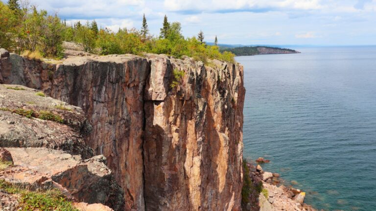
The headlands, cliffs, pebbly beaches and thick forests on this road trip really begin to shine beyond Two Harbors. Old and new MN 61 merge to become one highway that climbs bluffs and passes through tunnels. From the various overlooks, massive Lake Superior looks like an ocean, but its crisp, clean smell is that of the world’s largest freshwater lake by surface area. By comparison, the saline Caspian Sea is earth’s largest lake and Russia’s Lake Baikal is the world’s deepest freshwater lake. Formed by volcanoes and glaciers, Lake Superior contains more water than the other four Great Lakes combined, so big it has its own weather patterns.
More than 200 rivers feed Lake Superior and in Minnesota this means a lot of waterfalls. From Two Harbors, it’s 13 miles northeast to Gooseberry Falls State Park with a campground, several hiking trails and five waterfalls.
From Gooseberry, it’s just seven more miles to Split Rock Lighthouse State Park. While the shoreline, lake views, hiking trails and camping are highlights, the star is the lighthouse. Perched on a cliff and offering tours, the stately 1909 lighthouse is one of the most photographed sites in Minnesota.
From Split Rock, Tettegouche is the next state park and you’ll want to stop first at Palisade Head, about 11 miles from Split Rock. This chilling feature isn’t for those who fear heights. Palisade Head is the highest cliff on Lake Superior, plunging 300 feet to the water below. There’s no fence or rail. Rock climbers fearlessly scale the walls, adding to the intensity. It’s another two miles up MN 61 to the main part of Tettegouche State Park with more campgrounds, trails and waterfalls. The steep lake overlooks and beaches are particularly gorgeous.
After Tettegouche another sting of pretty parks extend up MN 61: George Crosby Manitou State Park, Caribou Falls State Wayside, Temperance River State Park and Cascade River State Park. So, there are plenty of options for camping, fishing, kayaking and hiking on busy summer weekends and holidays.
Grand Marais is the next major town, 50 miles from Tettegouche State Park. Geared to tourists, Grand Marais has crafts, coffee, ice cream and an attractive boat-filled harbor.
Grand Marais is also the start of another inspirational road trip, the Gunflint Trail Scenic Byway. This 56-mile one way trek on paved County Road 12 goes away from Lake Superior and deep into Minnesota’s North Woods. The byway passes through the highest parts of Minnesota with countless lakes, endless trees and lots of potential wildlife sightings. Watch out for moose. The road dead ends at Trail’s End Campground and the Boundary Waters Canoe Area Wilderness, just a short distance from Canada.
Back in Grand Marais and following Lake Superior northeast, North Shore Scenic Drive is now in the heart of Superior National Forest, where woodlands run to the edge of the Great Lake. From Grand Marais it’s 14 miles to Judge C.R. Magney State Park where a two-mile roundtrip hike leads to Devil’s Kettle, a remarkable waterfall where half of the cascade disappears into a hole after flowing around a large outcropping.
From Judge C.R. Magney, it’s 21 miles on MN 61 to Grand Portage National Monument. The Canadian border is just a few minutes farther. Situated in the present-day homeland of the Grand Portage Anishinaabe, the monument preserves a major fur trade area from the late 1700s. As the National Park Foundation notes, “Before the United States and Canada existed, the trading of furs, ideas and genes between the Ojibwe and French and English fur traders flourished.” The monument is a living history museum with interpreters and demonstrations. Housing more than 100,00 objects, it includes an impressive recreation of the North West Company Depot as well as native Anishinaabe artwork and a collection of canoes. In August, the monument hosts Grand Portage Rendezvous Days. The free two-day event is open to everyone and includes music, dancing, craft demonstrations and hands-on workshops. And you’re not required to wear period clothing! At the same time, the Grand Portage Band hosts a powwow within walking distance of the monument.
Grand Portage is also a launching point to Michigan’s Isle Royale National Park which lies a few miles offshore within eyesight of the mainland. The island is only accessible by water or seaplane and no vehicles are allowed.
Six miles from the monument and bordering Canada is the last of the eight state parks located along the scenic byway. There’s no camping but Grand Portage State Park offers picnicking, hiking, an easy walk to Minnesota’s tallest waterfall and views of Canada across the Pigeon River. This is the byway’s end but if you want to cross into Canada, it’s 45 minutes to Thunder Bay. Like Duluth but larger, Thunder Bay is also an outdoor enthusiast’s heaven with an outstanding Lake Superior setting.
Great River Road – All-American Road – 575 miles
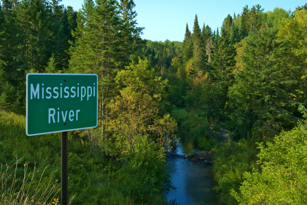
Its enormous size, habitat diversity and cultural importance are just some of the reasons the Mississippi River is America’s greatest waterway. For the river’s entire 2,552 miles, roads generally follow it, many times along both banks. From Wisconsin and Iowa to the Louisiana delta, these highways are designated as scenic byways. But Minnesota’s is particularly special because this is where the river begins. Without the North Star State, there wouldn’t be a Mighty Mississip’.
The byway starts at Itasca State Park in northcentral Minnesota, some 215 miles northwest of Minneapolis and about 100 miles northeast of Fargo, North Dakota. Itasca features more than 100 lakes and an old growth forest. Camping, fishing and birding are top pastimes. The Jacob V. Brower Visitor Center has educational exhibits and a gift shop. Following the lake five miles north is the Mary Gibbs Mississippi Headwaters Center where a short walk leads to the start of the river, so narrow you can step across! The Headwaters Center has an outdoor interpretive center on the area’s natural and cultural history.
Before heading south, the Mississippi flows north and so the byway zigzags to the northeast for 32 miles before reaching Bemidji, the first city on the river. A college town with all the basics, its most famous attraction is the oft photographed 18-foot-tall statue of Paul Bunyan and Babe the Blue Ox, made for the 1937 winter carnival. A mythical American folk hero, legend credits the burly, larger than life lumberjack for making canyons, rivers and lakes, such as Lake Bemidji, the one Paul and his faithful companion stand beside. Nearby, a bronze statue commemorates Chief Bemidji. Also known as Shaynowishkung, he lived by the lake in the mid-1800s and was a beloved member and spokesperson for the Ojibwa tribe. Bemidji is also known for a Spring Powwow that’s open to all and a downtown Sculpture Walk with more than 25 works of art you can see anytime.
From Bemidji, the byway heads east on US 2 through the Chippewa National Forest. This is lumber and lake country. With more than a thousand lakes in the area, fishing is big with numerous resorts set up for anglers seeking bass, crappies, perch, trout, walleye and muskellunge, aka “muskie.”
Grand Rapids is another good-sized town where Judy Garland was born. The star’s restored childhood home is now a museum and gift shop. The Forest History Center is the place to learn about the North Woods and lumberjacks. There’s an authentically recreated logging camp with cookshack, bunkhouse and blacksmith shop. Climbing the 100-foot fire tower puts the road trip in perspective with outstanding views of Grand Rapids, the Mississippi River and surrounding forests. The Itasca County Historical Society is a well-regarded local museum with exhibits on Native Americans, European settlers, the Mississippi, logging, the railroad and, of course, Judy Garland.
The Mississippi River then turns south for its long journey to the Gulf of Mexico. From Grand Rapids, the next interesting stop is 70 miles to Cuyuna Country State Recreation Area where abandoned mining pits and rock deposit stockpiles have been turned into lakes and biking trails. Boating, canoeing and fishing are popular. The area is mostly undeveloped but there is a campground. Potential wildlife sightings include red fox, mink, muskrat and beaver plus a lot of birds like bald eagles, great blue herons, ruffed grouse and many species of ducks and geese.
Brainerd lies 15 miles farther south with fuel, groceries and restaurants. Nine miles more is Crow Wing State Park, with woodsy hikes, camping and views of the Mississippi. The river is calm here so it’s a good place to try canoeing if you’re new to the sport. There’s also Old Crow Wing Village, the remnants of a frontier ghost town.
From Crow Wing, continue 23 miles south to Little Falls and the Minnesota Fishing Museum, Hall of Fame & Education Center. With so many freshwater lakes, the sport is very important to Minnesota: culturally, economically and as a treasured pastime. The museum displays more than 20,000 artifacts including lures, reels, canoes, boats, a re-created old-time fish camp, mounted fish and an aquarium with live native species. Little Falls is also where you’ll find another appealing state park. Charles A. Lindbergh has camping, canoeing, birding and canoeing on the Mississippi. It sits adjacent to Charles Lindbergh House and Museum, the childhood home of the aviation pioneer who piloted the first nonstop solo flight across the Atlantic. The museum includes exhibits, model planes, historic flight footage and a replica of the Spirit of St. Louis cockpit.
From Little Falls, it’s 33 miles to St. Cloud. So far, it’s the biggest city along the Great River Road where restaurants, breweries and bakeries abound. The Munsinger Clemens Gardens are a top sight with two distinct botanical gardens. Set on the banks of the Mississippi, 14-acre Munsinger features meandering flower-bordered paths under tall pines. Across the road on a hill, seven-acre Clemens is more formal and European-style with fountains and a rose garden.
Horticulture and agriculture are also on display at the Oliver Kelley Farm, 40 miles southeast of St. Cloud in Elk River. Ideal for kids, the 1860s homestead has a barn, farm animals, fields, tools, machinery and an historic house. Nature trails along the Mississippi wind through forest and rejuvenated prairie.
The first major metropolis the Mississippi passes through is Minneapolis, about 32 miles southeast of Elk River. Read our entry below on the Grand Rounds Scenic Byway to learn about the river-related attractions in Minnesota’s largest city.
Moving onto Minneapolis’ “twin” and the state capital of Minnesota, St. Paul is home to the Mississippi River Visitor Center. It’s run by the National Park Service with displays on the river’s biology, history and culture. The visitor center sits just off the lobby of the Science Museum of Minnesota. Anchored by the five-story-high Giant Astronaut floating in the atrium, the Science Museum’s exhibits include the Mississippi River and Dinosaurs & Fossils galleries. Displays at the nearby Minnesota History Center cover Minnesota’s Native communities, farming, mining and the state’s crazy weather. While the Visitor Center is free, the Science Museum and History Center charge admission.
Heading back into the countryside, the Great River Road leaves the city and travels 60 miles southeast to 2,300-acre Frontenac State Park, a gorgeous setting on bluffs overlooking the Mississippi with Wisconsin just across the river. Featuring prairie and forest topography, Frontenac is known for hiking and fall colors. Fishing, swimming and boat tours are popular, too, but the park is particularly notable for its birdlife. More than 260 species have been recorded and it’s one of the nation’s best spots to observe spring and fall migration. The campground sits on the edge of a bluff, 430 feet above the Mississippi.
From the park, it’s 23 miles down the river to Wabasha and the National Eagle Center. This section of the Mississippi is known for bald and golden eagles. The center has several non-releasable bald eagles and offers demonstrations as well as “floating classroom” experiences on river cruises and land-based habitat tours led by naturalists.
Winona is another 32 miles south. Once a bustling river port, the town now tempts visitors with an historic Victorian downtown, donuts from the iconic Bloedow Bakery and rock climbing on Sugar Loaf Bluff. Over two decades, the well-regarded Great River Shakespeare Festival has become a summer tradition. And the Minnesota Marine Art Museum showcases historical and contemporary work inspired by water in a stunning location along the Mississippi.
From Winona, the Great River Road parallels the Mississippi another 50 miles to the Iowa border. Our article on the Hawkeye State’s segment of the byway picks up the road trip from there. La Crescent lies 27 miles south of Winona on the Great River Road and is the start of the Historic Bluff Country Scenic Byway, profiled below.
Grand Rounds – National Scenic Byway – 52 miles

There aren’t a lot of metro areas with scenic byways that travel completely inside the city limits. But Minneapolis isn’t your average American town. The city’s abundant leafy, green parks, trails, lakes and parkways are just a few examples of how Minneapolis emphasizes a high quality of life. The Grand Rounds Scenic Byway connects many of these outdoor jewels. The system was first called “Grand Rounds” by William Watts Folwell in 1891. He was an educator, writer, historian and the University of Minnesota’s first president. For decades the Grand Rounds has been considered a top American urban parkway system. The byway is also one of the country’s longest continuous city routes, winding for more than 50 miles.
Naturally, the Mississippi plays a central role with this byway. As the river passes through the center of Minneapolis and neighboring St. Paul, the water and its banks are essentially one nonstop park. Two miles northwest of downtown Minneapolis, the Grand Rounds Scenic Byway starts at Ole Olson Park. Referred to as both West River Road and Great River Road, this part makes up a tiny section of the extensive byway running from northern Minnesota to the Gulf of Mexico, as profiled above.
Paralleling the river to downtown, walking trails and bikeways are found along the road. Minneapolis has many outstanding attractions but this itinerary will focus on ones specific to Grand Rounds. The first stop includes a waterfall, bridge and old mill. Look for paid parking at Stone Arch Parking where a short walk leads to St. Anthony Falls. For a different angle on the waterfall, head across Stone Arch Bridge. Completed in 1883 for trains, today only pedestrians follow the gorgeous 20-plus limestone arches and spans across the Mississippi. In a city filled with museums, the Mill City Museum is unique with spectacular views of the bridge and falls. At one time, Minneapolis was called the “Flour Milling Capital of the World.” The railroad transported Midwest grain and the river powered what was once the planet’s largest flour mill. The Baking Lab, Water Lab and eight-level Flour Tower tell the story while an observation deck provides panoramas of the river and city.
From the museum and downtown, continue south along the West River Parkway five miles to Mississippi Gorge Regional Park. Set on steep bluffs in hardwood forests, it offers more biking and walking along the Mississippi with excellent fall colors.
Two miles farther is Minnehaha Regional Park, one of the city’s most beautiful and popular parks. Though it runs along the Mississippi, the park is centered on Minnehaha Creek which flows into the Mississippi here. The park has gardens, limestone bluffs and river overlooks but it’s best known for 53-foot-high Minnehaha Falls. Though Henry Wadsworth Longfellow never saw the waterfall in person, he wrote about it in The Song of Hiawatha, turning Minnehaha Falls into a world-famous site. The nearby Longfellow House is a renovated 1906 replica of the poet’s home in Cambridge, Massachusetts. It’s now the information center for the Grand Rounds National Scenic Byway.
From Longfellow house, go another three miles south to Historic Fort Snelling. It’s position at the confluence of the Mississippi and Minnesota rivers made it strategically important to the U.S. military. Completed in 1825, the fort’s location was spiritually significant to the Dakota people for centuries. They called it Bdóte, meaning “meeting of waters.” Before the Civil War, soldiers were allowed to bring their personal enslaved people. In the 1830s, Dred Scott and his wife, Harriet, lived at the fort and then eventually sued for their freedom. In the infamous Dred Scott v. Sandford decision, the U.S. Supreme Court ruled that enslaved people were not U.S. citizens and thus, couldn’t expect protection from the federal government. During the US-Dakota War of 1862, Fort Snelling held non-combatant Dakota people in an outdoor camp. It’s estimated that 130 to 300 of them died during the winter from measles, other diseases and the harsh conditions. Today, the fort has a visitor center with exhibits and guided tours of the buildings and grounds.
Fort Snelling is adjacent to Minneapolis–Saint Paul International Airport. From here, the route changes direction, moving away from the Mississippi River and heading four miles north and west to Lake Nokomis, named for Hiawatha’s grandmother in Longfellow’s The Song of Hiawatha. It’s one of three sailing lakes in the Minneapolis park system. Canoeing, kayaking, boating, paddle boarding and biking are also popular and rentals are available.
Next, it’s another four miles northwest to Chain of Lakes and the shorelines of Bde Maka Ska, Brownie Lake, Cedar Lake, Lake of the Isles and Lake Harriet, each offering a myriad of activities. The Roberts Bird Sanctuary and Lyndale Park Gardens are highlights.
Trails connect the Chain of Lakes and as you move north, the byway is now west of downtown Minneapolis. The route then crosses I-394 to Theodore Wirth, the city’s largest park. Sports like golf, disc golf, tennis, archery, kayaking, mountain biking and cross-country skiing are big here. The Eloise Butler Wildflower Garden and Bird Sanctuary shows off the park’s softer, more serene side. These are the byway’s main highlights. Check out the Minneapolis Park and Recreation Board’s website for specifics.
Paul Bunyan – National Scenic Byway – 55 miles
About a 2.5-hour drive northwest of Minneapolis is an area of forests and lakes that’s been popular with travelers for generations. Winding through the heart of Minnesota, the charm of this road trip isn’t about visiting specific attractions. Instead, it’s an experiential journey of biking, hiking, birding, kayaking and relaxing in cabins and lodges. Whichever way you choose to meander, you’re never too far from a golf course or campground. For decades, fishing resorts have catered to anglers looking to hook bass, crappie, northern pike, sunfish, trout and walleye. Many restaurants feature the local catch on their menus.
Starting in Pine River, the byway makes two loops as it follows a series of paved county and state highways. Legend says the lakes around here were made by the boots of Paul Bunyan as the lumberjack strode through the countryside with ax in hand and Babe the Blue Ox by his side. Geologists will tell you that glaciers more likely formed the landscape. Nevertheless, Paul Bunyan and his tall tales figure prominently along this byway.
The Dakota people lived in this region until the 1700s when the Ojibwe moved in from the east. Europeans introduced the fur trade, logging and mining. Today, tourism drives the economy. Pine River is one of a handful of communities with restaurants, gift shops, art galleries, fuel and supplies. It also has a visitor center with byway info and maps. From Pine River, the drive east on County Road 1 passes through forests and agricultural fields while skirting to the north of the 14 interconnected Whitefish Chain of Lakes. Side roads lead to the shores.
At County Road 66, go south to County Road 16 which heads back west following the southern shores of Upper and Lower Whitefish lakes. Or continue south on County Road 66 to the town of Crosslake where the late 1800s-era Crosslake Historic Log Village preserves several buildings furnished with artifacts. From Crosslake, take County Road 3 south to County Road 11 and go west to Breezy Point. The route then continue onto Pequot Lakes, another small community with a water tower painted to look like Paul Bunyan’s fishing bobber.
Driving Minnesota State Highway 371 north, it’s ten miles from Pequot Lakes to Pine River. Running parallel to the scenic byway for a short way is the 115-mile Paul Bunyan State Trail, the longest continuously paved rail-trail in the U.S. Constructed for biking, walking, running, in-line skating and snowmobiling, the south-to-north trail extends from Crow Wing State Park to Lake Bemidji State Park.
This byway runs just west of the lengthy Great River Road, as profiled above. From Crosslake, it’s about ten miles to the Mississippi River and 20 miles to Cuyuna Country State Recreation Area.
Historic Bluff Country – National Scenic Byway – 88 miles

While lakes and rivers shine in the other Minnesota byways profiled in this article, the Historic Bluff Country Scenic Byway is more about hills, forests, apples, Amish and Laura Ingalls Wilder. The route traverses the far southeast corner of Minnesota, starting at the Wisconsin state line and traveling just north of the Iowa border. Our earlier entry on the Great River Road followed that byway as it ran parallel to the Mississippi River through much of Minnesota. Historic Bluff Country takes off from the Great River Road at La Crescent, a small town across the Mississippi from La Crosse, Wisconsin and 23 miles north of the Iowa line.
La Crescent is the “Apple Capital of Minnesota” and there’s even the Apple Blossom Drive Scenic Byway north of town if you’d like to view orchards growing in the bluffs overlooking the Mississippi River. There are fruit stands, a weekly farmers market and an annual apple festival in September that showcase the different varieties grown in the area, including Honeycrisp, the official state fruit which was developed by the University of Minnesota in the 1960s.
From La Crescent, the road trip heads south and then west. The entire byway and Minnesota State Highway 16 are largely one in the same, so this scenic route is easy to navigate. The byway follows the Root River through an expressive landscape of valleys, limestone bluffs, caves and sinkholes created over millions of years by geological activity and erosion.
Ten miles from La Crescent, the byway passes through Mound Prairie Scientific and Natural Area with hardwood forest and something the locals call “goat prairies” which are grasslands with photo-worthy summer wildflowers. A short hike to the top of the bluffs offers great views.
Minnesota puts a lot of effort into its state trail system and 7.5 miles from Mound Prairie, the byway enters Houston, the start of the Root River State Trail. Running 42 miles along the Root River from the Houston Nature Center to Fountain, the paved trail was built on an abandoned railroad and is designed for hiking, biking, in-line skating and cross-country skiing.
From Houston, it’s 12 miles to Rushford with fuel, a hardware store and Norsland Lefse. The coffee shop, bakery and gift shop specializes in Scandinavian treats, specifically lefse, a traditional Norwegian food made from potatoes, flour, salt and vegetable oil. Outside of town is the Rushford Sand Barrens Scientific and Natural Area, noteworthy for its plant diversity, wildflowers and birding.
Continuing west from Rushford Sand Barrens, the byway zigs and zags for 15 miles to Lanesboro, a little town that’s landed on many “best of” lists over the years including Forbes’ “America’s Prettiest Towns,” Smithsonian Magazine’s “20 Best Small Towns” and ArtPlace America’s “Top 12 Small Town ArtPlaces.” Lanesboro is also called the “Bed & Breakfast Capital of Minnesota.” So, it’s no surprise you’ll find plenty of quality art, shopping and eating in its historic 19th century downtown. Lanesboro is in Fillmore County which has Minnesota’s largest Amish settlement. A couple of companies in town offer tours.
Next, follow MN 16 to nearby Preston where the paved 18-mile Harmony-Preston Valley State Trail starts at Preston Trailhead Park. By bike, it’s 5.5 north to the Root River State Trail. Preston operates a free bike share out of City Hall or you can rent from shops in Lanesboro.
From Preston, it’s 16 miles to Forestville/Mystery Cave State Park with camping, fishing and horseback riding. However, the main draws offer two completely different experiences. In 1868 Forestville began to slowly die after the Southern Minnesota Railroad bypassed the town causing merchants and farm families to gradually leave. Today, Historic Forestville is what remains with a late-1800s store, farm, homestead with original artifacts and visitors center. A couple of miles away and below ground is Mystery Cave, the longest cave in Minnesota. Stalactites, stalagmites and underground pools are found within its 13 miles of underground passages. Park naturalists lead tours all summer and on spring and fall weekends.
Back on the byway, follow MN 16 to Spring Valley. Laura Ingalls Wilder, the beloved author of the Little House books, lived here with her family in the 1890s after a series of serious personal setbacks, including recovering from diphtheria. Laura and husband Almanzo attended Spring Valley Methodist Church which is now a museum exhibiting Wilder memorabilia and other local relics.
As MN 16 moves westward, the bluffs, forests and valleys give way to farmland. About five miles from Spring Valley, look for Four Daughters Vineyard & Winery, known for first-rate wine and cider. The byway ends 11 miles farther at Dexter where the highway meets I-90.
Minnesota River Valley – National Scenic Byway – 300 miles

Just east of the Minneapolis–Saint Paul International Airport, the Minnesota River flows into the Mississippi at Historic Fort Snelling, as profiled in our earlier Grand Rounds Scenic Byway story. But if you follow the Minnesota River west, you leave the suburbs for rolling farmland, lush valleys, forests and prairies. It’s a drive abundant in historical sites and museums, too. The road trip follows the river some 300 miles to South Dakota, and it can be confusing because the route includes different highways and river crossings. So, look for signs with an eagle marking directions. The byway also has a useful website with maps and information.
The Minnesota River Valley Scenic Byway officially starts 45 miles southwest of downtown Minneapolis in Belle Plaine. Six miles west of town, check out Kerfoot Canopy Tour, a highly rated zipline and high ropes course for ages seven and older. From here, continue seven miles south to Henderson and then cross over the Minnesota River to the 446-acre Ney Nature Center. The forest, prairie and pond habitats provide hiking, birding and wildlife viewing. Unique events include a monarch butterfly tagging program and maple syrup tours. Each spring, the nature center taps more than 100 trees with bottles available for purchase.
The Ney Nature Center also manages and gives tours of the W.W. Mayo House, just down the byway in La Sueur. This small 19th-century Gothic-style home was hand-built by Dr. William W. Mayo. It held his first medical practice which evolved into the world-renowned Mayo Clinic.
Before Europeans arrived, the Dakota lived in this region for centuries. From La Sueur, it’s ten miles to the Treaty Site History Center and Traverse des Sioux where an 1851 treaty was signed between the Dakota and U.S. government. The Treaty of Mendota was signed that year, too, and together the agreements opened millions of acres of land to settler-colonists. The treaties had tragic consequences for the Dakota. As the Minnesota Historical Society describes it, “By 1862, stripped of their land and left without the food and money promised them, the Dakota were starving.” Displays at the history center give details on the treaties and history of the Dakota as well as the explorers, traders and settlers who led Minnesota’s territorial expansion. Outside you can walk the adjacent Traverse des Sioux, a busy meeting place and trading post on the Minnesota River for thousands of years.
The Treaty Site History Center lies on the northside of St. Peter, home to Gustavus Adolphus College. The campus has a beautiful Arboretum with gardens and miles of trails through prairies, pine forests and maple groves.
From St. Peter, it’s 13 miles south to Mankato, the largest city along the byway where art, coffee, food trucks and restaurants are a priority. There’s a lot to see in the downtown area:
- CityArt Walking Sculpture Tour features outdoor sculptures, murals and monuments displayed year-round.
- Historic Blue Earth County Courthouse was built in 1894 in perhaps the best-named county in America: Blue Earth!
- Blue Earth County History Center and Museum has exhibits on local heritage including a pioneer cabin and barn, diorama of 1880s Mankato and treasures from local author Maud Hart Lovelace.
- Betsy-Tacy Houses Literary Landmarks are a museum, interpretive center and gift shop located in two restored homes. They’re dedicated to Mankato native Maud Hart Lovelace who wrote the children’s series of Betsy-Tacy books. The museum, Betsy’s House, is refurbished to look as it did when Lovelace lived there from 1892 to 1906.
- Historic R.D. Hubbard House dates to 1871 and is considered one of the finest examples of French Second Empire architecture in Minnesota. The 16-room mansion and furnishings are in their original form, and the grounds include Victorian gardens and a carriage house with horse-drawn vehicles and antique automobiles.
- Minnemishinona Falls drop 42 feet over a rock ledge. The waterfall is located five miles west of Mankato on Judson Bottom Road.
The byway now begins its westward trek, starting five miles west of Mankato at Minneopa State Park. It’s on the southside of the Minnesota River, directly across from Minnemishinona Falls. The name Minneopa, “water falling twice,” comes from the Dakota language and refers to the park’s double waterfall. Follow Bison Drive Road through 325 acres of range to see the resident herd of about 40 bison. There’s also the 1864 Seppmann Windmill that could grind 150 bushels of wheat into flour on a day with good wind. However, it’s been missing arms since an 1890 tornado. Camping, fishing and birding are also part of this park’s experience.
Minneopa’s windmill was built by Louis Seppmann, a German native. From the state park, it’s 22 miles to the next charming community, New Ulm, founded by German immigrants in the 1850s. Considered the most German town in Minnesota, there’s German food, German shops and a German brewery. In fact, August Schell is the oldest brewery in Minnesota and the second oldest family-owned brewery in the U.S. Throughout the day in Schonlau Park, the 45-foot-tall Glockenspiel’s bells chime while 12 figurines rotate on a circulating stage. Stop by the Brown County Historical Society to learn more about New Ulm’s colorful heritage. The museum’s distinct German Renaissance-style building is itself a gorgeous showpiece.
From New Ulm, it’s 17 miles northwest to Fort Ridgely State Park. Set in scenic rolling hills, the park has camping, trout fishing, horseback riding and hiking through prairies and woodlands. History is the other big draw. Completed in 1855, the fort’s population numbered some 300 soldiers and civilians. During the US-Dakota War of 1862, it withstood two major attacks and later became a training ground for Civil War recruits. Fort Ridgely’s time as an active military post ended in 1872.
From Fort Ridgely, go another 17 miles northwest to Lower Sioux Agency State Historic Site near Morton. Managed by the Lower Sioux Indian Community, this marks the first battle of the US-Dakota War of 1862. The history center has exhibits on Dakota history, culture and the events that led to the war. Trails lead to the restored 1861 stone warehouse and the site of the Battle of Redwood Ferry.
Redwood Falls is another 11 miles west. It’s well-appointed with fuel, restaurants and pharmacies. The prettiest spot in town is also one of the biggest in the state. Nicknamed “Little Yellowstone of Minnesota,” 256-acre Ramsey Park is Minnesota’s largest municipal park with camping, a zoo and the lovely Ramsey Falls. The Redwood Falls Golf Club is adjacent.
Another natural beauty lies 40 miles northwest of Redwood Falls. With grasslands, wetlands and woods, Upper Sioux Agency State Park has a diverse terrain for hiking, birdwatching and horseback riding. There’s camping, including three canvas tipis.
For something completely different, go eight miles west of the state park to the self-guided Fagen Fighters WWII Museum. Located south of Granite Falls, it houses a large collection of fully operational aircraft, including fighters, bombers and trainers. There are also jeeps, a tank buster, bulldozer, motorcycles and artwork.
It’s just another seven miles south on Minnesota State Highway 23 to Minnesota’s Machinery Museum in Hanley Falls. The stories of generations of farm life are told through implements, tools, tractors, gas engines and rural art in four large buildings.
Heading back to the northwest again, the byway leads to Montevideo with a brewery, fast food and Historic Chippewa City where 24 buildings on 20 acres replicate a late 1800s village. The preservation project began in 1965 with a one room schoolhouse and has grown to include a church, bank, general store, blacksmith shop, hat shop and log cabins.
Driving northwest out of Montevideo, follow the Minnesota River 12 miles to the start of Lac qui Parle Wildlife Management Area, a vast 33,000-acre expanse of rivers, lakes, wetlands, woodlands and prairie, vital to the Dakota for thousands of years. Set up camp at Lac qui Parle State Park and then canoe, kayak and hike. Fishing and hunting are primary activities, too. The name is a French translation for what the Dakota called the “lake that speaks.” In spring and fall, thousands of noisy migratory Canada geese and other waterfowl stop at Lac qui Parle. For history buffs, check out the nearby Fort Renville Historic Site, an 1820s fur trading post and Lac qui Parle Mission, established by Christian missionaries in 1835. The poet Robert Bly grew up in these parts, and 16 miles west in Madison, the Lac qui Parle History Center displays his study along with a furnished 1870s log cabin, 1880s schoolhouse, 1933 gas station, wagons, farm machinery and tools.As the byway approaches South Dakota, 35 miles northwest of Lac qui Parle State Park is Big Stone National Wildlife Refuge. Drive or bike the five-mile Auto Tour Route through wetlands, woodlands, prairie and granite outcrops. A few miles farther and the highway reaches Ortonville. Then, it skirts the eastern shore of 26-mile-long Big Stone Lake, the source of the Minnesota River. Big Stone Lake State Park has waterside camping, boating and fishing for bluegill, northern pike, perch and walleye. It’s another 25 miles to the byway’s end in Browns Valley, on the South Dakota state line.