The Grand Canyon is, well, grand—it’s truly a destination unlike any other. It’s also one of the most beloved destinations for serious hikers—and when we say serious, we mean it. These trails often go downhill before requiring a steep uphill climb, and the desert sun and exposure means they’re anything but easy.
The vast majority of visitors to Grand Canyon National Park find themselves at the South Rim—which is, after all, where the National Park visitors centers, developed campgrounds and other facilities exist. Only 10% of visitors are dedicated and adventurous enough to make their way to the North Rim, which is exactly why it’s the place to go for those looking for crowd-free hiking trails.
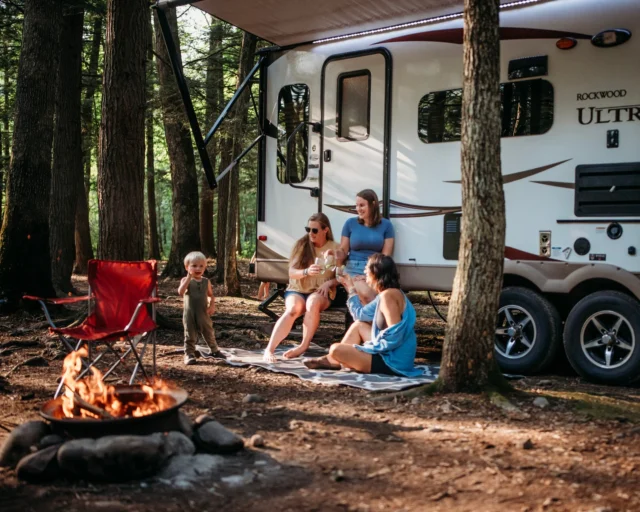
RV camping is easily the best way to enjoy the less-crowded trails at the Grand Canyon, precisely because it allows you to get up close and personal with these off-the-beaten-path areas while still retaining the comforts of home. Though you might not find a KOA at the North Rim—which truly is one of the most remote locations in our country—you can still carry everything down to the kitchen sink and a cozy bed with you. It sure beats tent camping in the middle of nowhere!
Best Crowd-Free Trail Suggestions by AllTrails
Serious hikers probably already know the magic of AllTrails—an app dedicated to all things outdoors, whether you’re into hiking, mountain biking, or tamer nature walks. We’ve partnered up with AllTrails to bring you the best unique hiking experiences across a variety of our country’s most popular national parks. And yes, AllTrails has plenty of crowd-free trails listed—even at the Grand Canyon.
Although the basic AllTrails Base membership is free to (and super useful!), an AllTrails Plus membership gives you access to offline maps, 3D trail previews, wrong turn alerts and more. And if you’re really ready for adventure, an AllTrails Peak membership gives you the opportunity to create your own routes from scratch, get real-time ID help on local plant life, and so much more. (Psst: We’ve also got the hookup! For a limited time, AllTrails is offering our readers 30% off an AllTrails Plus membership. Score! 🥾)
Alright, without further ado, let’s dive into the best crowd-free hiking trails around the Grand Canyon.
Skip: South Kaibab to Ooh Ahh Point, Cedar Ridge, or Skeleton Point; Instead, Try Widforss Trail or Cape Royal Trail
South Kaibab trail is, without a doubt, one of the main arteries of the South Rim. With its trailhead located within walking distance of Mather Campground and the opportunity to take it as far or (or not) as you like—it even runs across the river and back up the other side as North Kaibab trail!)—it’s no surprise that so many visitors flock to this trail to explore the canyon to a level custom-built to their comfort. (From this list, South Kaibab to Ooh Ahh Point is the easiest at about two miles and 700 feet of elevation change round trip, followed by South Kaibab to Cedar Point at three miles round trip and 1,200 feet of elevation change, and South Kaibab to Skeleton Point coming in at the hardest and longest at just under six feet altogether and 2,000 feet of elevation gain, all of which happens on the way back up, when you’re already tired.)
We have two less-popular (but no less stunning!) trails on the North Rim to offer you instead of these very beautiful but also very crowded South Rim options. Those are the Widforss Trail, which clocks in at almost 10 miles long but is still considered a moderate trail with its well-graded 1,000 total feet of elevation gain, and the short and easy Cape Royal Trail, which is a mere one mile round trip and just about flat, but offers a huge bang for its buck in the way of sweeping canyon views. (It’s pretty tough to find a hike in the Grand Canyon marked as “easy,” but Cape Royal Trail makes the cut!)
Both of these trails offer wide panoramic views of the Grand Canyon, with the Widforss Trail also giving visitors a chance to experience some high-desert pine canyon. The Widforss Trail is named for Swedish artist Gunnar Widforss, who spent much of his early 20th century career attempting to capture this one-of-a-kind world wonder. Those who tackle the trail will easily be able to see what had him so inspired.
The Cape Royal Trail, on the other hand, is an excellent option for travelers who may be less physically able to take on longer or more strenuous hikes. The trail is gentle and paved, making it one of the park’s only wheelchair-friendly options, and it’s also tame enough for those with small children in tow.
Here’s what real, live hikers have to say about their experiences with these two trails:
Widforss Trail:
- Stunning hike. Of course incredible views of the canyon, but we also loved the varied terrain.
- Great trail with views of the rim broken up by hikes through the forest. Up and down are broken up along the way. Fantastic views at the end.
- The AllTrails description is pretty accurate but did not mention the verdant meadows full of ferns. Stunning… I was shocked!
Cape Royal Trail:
- These views are more than worth the drive! The trail is paved and takes you to 3 different overlooks of the canyon. Easily the best views of our day!
- Views were absolutely amazing!!!! Several breathtaking lookouts on the trail, all with railing! Definitely our favorite trail of the day!!
- Absolutely breathtaking!
Before You Go Considerations
Any Grand Canyon hike should be taken seriously, because this is a serious wilderness landscape. Here’s what to know before you go to the Widforss Trail or Cape Royal Trail:
- Be sure to bring sunscreen. Many of the reviews for both of these trails reiterate this important safety consideration. Even in the shoulder seasons, the Arizona sun is no joke, and these trails are very exposed. So slather up!
- Carry enough food and water. A liter of water per person per hour is a good rule of thumb, and to keep your electrolytes in balance, load up with salty snacks.
- Be aware of wildlife. Although rattlesnakes, scorpions, and even mountain lions call the Grand Canyon home, surprisingly, many wildlife-related injuries come from none other than rock squirrels, which look cute and cuddly but can deliver a mean (and potentially disease-infested) bite.
Skip Bright Angel Trail; Try Cape Final Trail Instead
It doesn’t really get any more classic than Bright Angel Trail—which means it doesn’t get any more crowded, either. Right after South Kaibab, Bright Angel Trail is what comes up at the top of the list of the best ten hiking trails in the Grand Canyon—a list that, notably, favors the South Rim. And at almost 16 miles and 4,500 feet of elevation gain altogether, this trail is anything but easy (although you can certainly make shorter trips of it along the way).
Still, for those ready for an off-the-beaten-trail gem (with far fewer strangers crowding your Insta snaps), Cape Final Trail is our pick. Far easier at just four miles round trip and a relatively tame 500 feet of elevation change, Cape Final offers interior canyon views that are just as stunning—if not more so, given their lack of others outside of your party—as well as a soft-footed forest hike along the way. (It’s also a family-friendly alternative, given its relatively more accessible length and elevation profile.)
Here’s what some recent real-life hikers had to say about Cape Final Trail:
- Beautiful forest walk out to magnificent canyon views.
- Parking area a little rugged but the rest of the hike is great. Easy hike for the family and great views from the rocks at the end. Decent amount of shade for an afternoon hike.
- Easy hike, well delineated trail. The view at the end was spectacular.
Before You Go Considerations
Along with what we already covered above, keep the following in mind:
- The North Rim is rugged, so be prepared. Not every vehicle can make it through the unimproved, rugged roads it takes to reach some of these trailheads, so be sure you’re driving an AWD vehicle with decent enough clearance.
- Gear up before you go. Additionally, ensure you have the right gear ready to go in your vehicle just in case you have an unexpected emergency: extra water and food, emergency blankets, a spare tire and a satellite radio can all mean the difference between an inconvenience and a catastrophe.
Post-Hike Resources for Grand Canyon National Park
Hiking is easily one of the most amazing things about the Grand Canyon—but there’s plenty else to see and do here, too.
For starters, there are some amazing campgrounds to consider for your trip, so you’ll have a comfortable home base to return to after the day’s adventures. While many of them are situated closer to the South Rim, there are a few more rugged camping opportunities along the North Rim, too. Just be sure for any campgrounds that require reservations that you book early; these popular spots tend to sell out fast!
If you’re on the North Rim, there aren’t a lot of options as far as nearby towns; your closest bet will be either Fredonia, Arizona (about 77 miles northwest of the Rim) and Kanab, Utah (about 84 miles northwest of the Rim), with the tiny town of Jacob Lake, Arizona being a little closer but offering little more than a quick fuel stop. (When you’re in the desert, fuel up often and treat half a tank as empty—if the station you’re counting on is out, you’ll be stuck.)
In Fredonia, the Red Pueblo Museum and Heritage Park is an interesting attraction that offers visitors a glimpse into the lives of the Anasazi and other Indigenous peoples who lived in this place before it was colonized. And just shy of the Utah border, Buckskin Tavern is the watering hole for when you just need a fresh, cold beer and a good conversation—and it’s also the longest bar in Arizona.
There are also, of course, plenty of wonderful RVshare rentals in the area to consider for your trip!
You can have a grand tour of the Grand Canyon without a stranger making a grand entrance into your photos. When you make the trek in an RVshare vehicle, you’ll bring all the comforts of home along for the ride—even in the wildest part of the park, the North Rim. (Just don’t forget to sign up for an AllTrails Plus membership so you can download the trail maps before you run out of signal range!)
Happy trails!